 AppGoblin
US Topo Maps

US Topo Maps was last scanned for SDKs 2025-09-22. Below is the overview of third party companies detected in the app. The full list of raw SDKs, app permissions and unknown SDKs is available here.
4.6★
Ratings: 10743
Screenshots


App Description
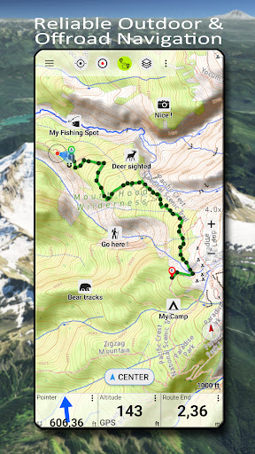
Offroad & Outdoor Navigation. Multiple Maps: Topo, Aerials, Nautical Charts, etc
Easy to use outdoor navigation app with free access to the best available maps and aerial imagery for the USA.
Choose between 30+ map layers (topos, aerials, sea charts, ...) to plan the perfect trip and
turn your Andoid Phone/Tablet into an outdoor GPS for offline trips into the backcountry.
Add easily maps from other sources (GeoPDF, GeoTiff, Online Map Services like WMS, ...)
Available basemap layers for USA:
• USGS National Map Topo
• USGS National Map Imagery Topo
• USGS National Map Imagery
• USGS NAIP HiRes Imagery
• USGS Topo traditional DRGs: Seamless coverage of topo maps of the USA at Scales 1:250.000, 1:100.000, 1:63.000 and 1:24.000/25.000
• FSTopo Forest Maps
• NOAA Nautical RNC Charts
• National Elevation Maps (Hillshade, Slope Map, Aspect Map)
Worldwide basemap layers:
• OpenStreetMaps (5 different map layouts), also downloadable in space saving vectorformat
• Google Maps (Satellite images, Road- and Terrain-Map)
• Bing Maps (Satellite images, Road-Map)
• Earth At Night
Configure a basemap layer as an overlay and utilize a transparency fader to seamlessly compare maps with each other.
Add maps from other sources:
• Import raster maps in GeoPDF, GeoTiff, MBTiles or Ozi (Oziexplorer OZF2 & OZF3)
• Add web mapping services as WMS or WMTS/Tileserver
• Import OpenStreetMaps in Vectorformat, eg complete USA for just some GBs
Available US map Overlays - add additional information to any other base map:
• Public Land Ownership (PAD-US 3)
• National Hydrographic Dataset
• Motor Vehicle Use Map (USDA)
• Elevation Contourlines
• 4WD Trails
• Trails
• Roads, Railroads, Airports
Available worldwide overlays:
• Hillshading overlay
• 20m Contourlines
• OpenSeaMap
There is no perfect map. Toggle between the different map layers or use the compare maps feature to find the most interesting route. Especially the old traditional DRGs contain many small pathes or other features that are missing on modern maps.
Main features for outdoor-navigation:
• Download map data for OFFLINE USAGE
• Measure pathes and aereas
• Create and edit Waypoints
• GoTo-Waypoint-Navigation
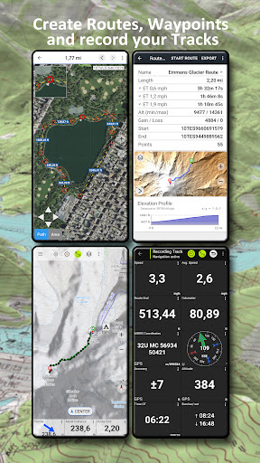
• Create and edit Routes
• Route-Navigation (Point-to-Point Navigation)
• Track Recording (with speed, elevation and accuracy profile)
• Tripmaster with fields for odome