 AppGoblin
onX Hunt: Offline Hunting Maps

onX Hunt: Offline Hunting Maps was last scanned for SDKs 2025-09-21. Below is the overview of third party companies detected in the app. The full list of raw SDKs, app permissions and unknown SDKs is available here.
4.69★
Ratings: 61708
Screenshots

App Description
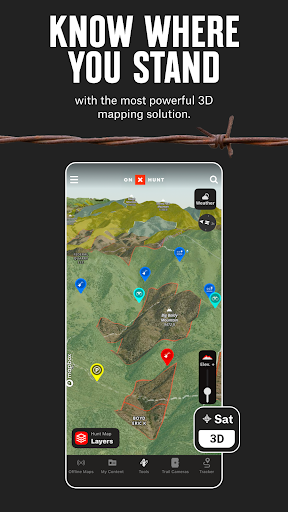
Plan your hunt with topo maps, property lines, GPS navigation, and map layers
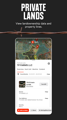
Navigate your next hunt with topo maps, GPS navigation, species distribution, hunting units, and more. Know where you stand by viewing private and public land ownership data and landowner names. Maximize your hunting experience with onX Hunt.
View topo maps to plan your hunt or toggle between satellite and hybrid Basemaps. Open 3D maps, mark crucial locations with Waypoints, and measure the distance to the nearest access point with Lines. Save Offline Maps to go as far from the grid as you want. Hunt by species and toggle Map Layers for deer, elk, turkeys, or waterfowl.
Map property lines to hunt with confidence and find new opportunities nationwide. Utilize offline navigation by downloading detailed maps with your Markups. Monitor weather conditions, wildlife distribution, and data on trees, crops or soil by switching between custom Map Layers. View Trail Cameras for recent activity and Wind Calendars for stand locations.
Access GPS navigation directly on your phone or instantly drop a Waypoint from your wrist using Wear OS. Explore a hunting app that enhances your efficiency in the field by giving you the recon tools you need.
Discover new access, find more game, and hunt smarter with onX Hunt.
onX Hunt Features:
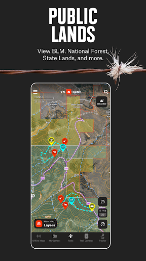
▶ Public & Private Land Boundaries
• Check property lines and land boundary maps with landowner names (U.S. only)*
• View Hunting Units or GMU to plan ahead. Study county and state land hunting maps
• Navigate public land with Forest Service or Bureau of Land Management (BLM) maps
• Observe state lines and locate Wildlife Management Areas, Timber Lands, and more
* Private land ownership maps may not be available for all counties (U.S. only)
▶ Offline Maps & Custom Layers
• Use 2D or 3D maps to understand the terrain and visualize your hunt
• Topo maps, satellite or hybrid Basemaps. Take advantage of easy-to-read visuals
• Save Offline Maps with your Layers, custom Markups, and Waypoints
• 7-day weather forecast. Study conditions or view wildlife and tree distribution
▶ Hunt Planner & Tracker
• Connect Moultrie trail cameras to see images in real time & receive key insights
• Measure distance between two points with the Line Distance Tools
• Map routes, mark locations, view Optimal Wind and save access points
• GPS navigation app. Log your hunt, monitor duration, distance, and speed