 AppGoblin
AlpineQuest Explorer Lite

4.57★
Ratings: 18712
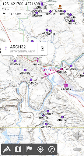
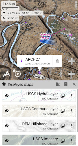
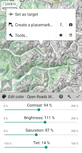
Screenshots
App Description
Turn your phone into a real off-road GPS using off-line topo maps!
No advertisements ~ No data sharing & monetization ~ No analytics ~ No third party libraries
AlpineQuest is the complete solution for all outdoor activities and sports, including hiking, running, trailing, hunting, sailing, geocaching, off-road navigation and much more.
You can access and store locally a large range of on-line topographic maps, which will remain available even while being out of cell coverage. AlpineQuest also supports many on-board file-based raster map formats.
By using the GPS and the magnetic sensor of your device (with compass display), getting lost is part of the past: you are localized in real-time on the map, which can also be oriented to match where you are looking at.
Save and retrieve unlimited placemarks, share them with your friends. Track your path, get advanced statistics and interactive graphics. You won’t have anymore questions about what you can accomplish.
By staying fully operational out of cell coverage (as often in mountain or abroad), AlpineQuest assists you in all your desires of deep wilderness exploring…
Don’t hesitate, use this Lite version right now for free!
PLEASE report suggestions and issues on our dedicated forum https://www.alpinequest.net/forum (no registration needed, all questions answered) and not in comments.
Key features are (for full version):
★★ Maps ★★
• Built-in online maps (with automatic local storage; road, topo and satellite maps included) and online layers (road names, hillshade, contours);
• Get more online maps and layers in one click from the included community maps list (all major worldwide maps and many local topo maps);
• Complete area storage of online maps for off-line use;
• On-board offline maps support (raster) including KMZ Overlays, OziExplorer OZFx2, OZFx3 (partly) and calibrated images, GeoTiff, GeoPackage GeoPkg, MbTile, SqliteDB and TMS zipped tiles (visit our website to get MOBAC, the free map creator);
• QuickChart Memory Map support (.qct maps only, .qc3 maps not compatible);
• Built-in image calibration tool to use any scan or picture as a map;
• Digital elevation model on-board storage (1-arcsec SRTM DEM) and support for HGT elevation fi