FlyQ+ EFB
FlyQ+ EFB Summary
FlyQ+ EFB is a with in-app purchases iOS app in the Maps And Navigation category, developed by Seattle Avionics, Inc.. First released 11 years ago(Oct 2014), the app has 839 ratings with a 4.05★ (good) average rating.
Data tracking: SDKs and third-party integrations were last analyzed on Nov 29, 2025.
Store info: Last updated on App Store on Jan 24, 2025 (version 6).
FlyQ+ EFB was last scanned for SDKs 2025-11-29. Below is the overview of third party companies detected in the app. The full list of raw SDKs, app permissions and unknown SDKs is available here.
4.05★
Ratings: 839
Screenshots


App Description
FlyQ+ EFB is a top-rated aviation app because it makes your flying easier and safer by thoughtfully integrating powerful features in a way that minimizes the number of screen taps and uses larger fonts to increase readability.
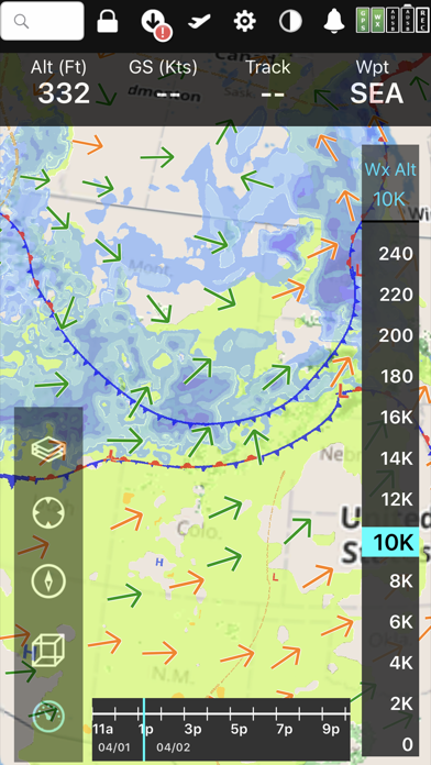
New features such as a glide ring, graphical weather briefing, ability to download two data cycles, and a navlog that expands/collapses airways/SIDs/STARs make flying safer and easier than ever before!
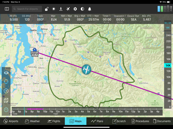
The Global Digital Map shows airports, airways, airspace, navaids, and waypoints from all around the world. Text rotates so it's always right-side up and the level of detail adapts to the zoom level.
Our exceptional "4D Predictive Weather" system uses a Timeline and Altitude Slider to help you analyze weather at different times - both past and future - and at different altitudes. 17 weather layers from both the Internet and ADS-B (e.g. Radar, Icing, Turbulence, PIREPs, Winds Aloft, Surface Winds, Surface Analysis, Satellite, and more), many tied to the Timeline and Altitude Slider, give you unprecedented pre-flight and in-flight safety.
Supports more than 20 ADS-B and in-panel devices: Stratus 3, Avidyne, Dynon, Stratux, and more.
The exclusive Augmented Reality (AR) feature provides situational awareness you'd previously only seen in sci-fi movies.
The Slingshot wireless system means FlyQ+ supplies maps, plates, and apt diagrams wirelessly to certified systems from BendixKing.
The Visual Logbook and Post Flight Playback / Analysis Graphs add a whole new dimension to your flying. Optionally connect with your friends to "see" and even replay their flights. CFI's can track student progress and remotely send endorsements.
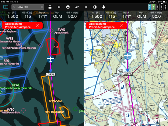
Other key features include split screen, 3D synthetic vision, plates on the map, more than 4,600 airport diagrams, rich Documents support, extended runways, distance measurement, fuel prices, NOTAMS, wind-optimized flight planning, and plates for Mexico and Central America.
NEW! NaviGuard GPS anomaly detection guards against GPS spoofing and jamming
> Maps Your Way
+ Digital, 2D maps, 3D Syn Vis, Augmented Reality
+ Sectionals and IFR charts
+ TACs
+ Photo, road, terrain maps
+ 17 Weather Layers
+ Flight Track
+ Fuel Prices
+ TFRs
+ Obstacle and Terrain Avoidance
+ ADS-B Traffic and Weather
+ Extended runways with right-pattern indicators
+ Procedures on map
+ Rings / Extended Course Line
+ CAP grid
+ Heli