Pro Altimeter - Barometric+GPS
Pro Altimeter - Barometric+GPS Summary
Pro Altimeter - Barometric+GPS is a mobile iOS app in Maps And Navigation by Craig Hunter. Released in Nov 2014 (11 years ago). It has 42 ratings with a 4.00★ (good) average. Based on AppGoblin estimates, it reaches roughly 173 monthly active users . Store metadata: updated Sep 28, 2025.
Store info: Last updated on App Store on Sep 28, 2025 .
4★
Ratings: 42
Screenshots


App Description
Pro Altimeter uses the high-fidelity barometric pressure sensor in iOS devices to measure and compute altitude.
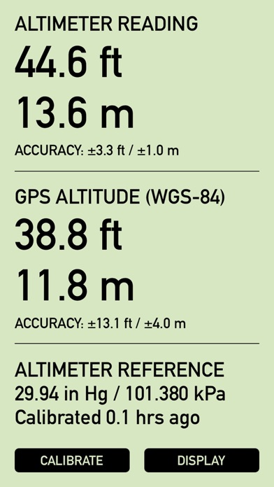
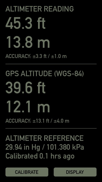
Pro Altimeter has a dead simple interface. Barometric altitude and GPS altitude are displayed in large easy to read numbers, showing units of both feet and meters, and giving realtime accuracy estimates from the hardware. At bottom are calibration and display mode buttons. The display offers a highly-readable daytime mode with black digits on an LCD-green background, and a reversed night mode that is easy on the eyes in dark conditions. That's it!
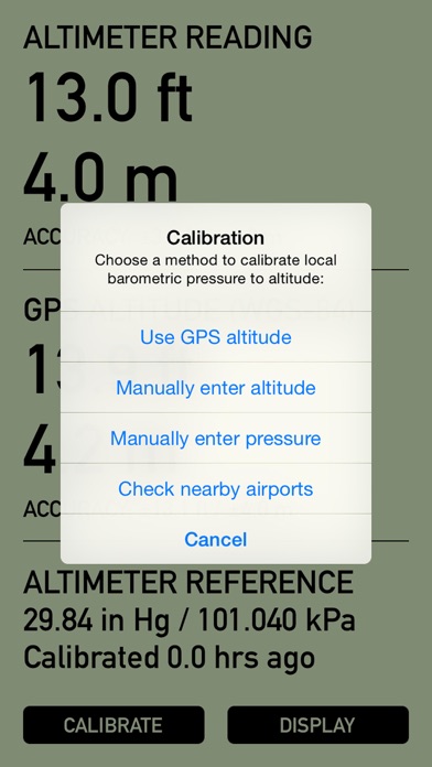
Proper calibration is necessary to measure altitude from barometric pressure (this is why a pilot "dials in" the cockpit altimeter before taking off). Pro Altimeter offers four different methods for calibration -- choose the easiest and most convenient:
1. Use GPS altitude. This method correlates the measured local barometric pressure with the altitude measured by GPS. This method can be used when your device has a clear line of sight to the sky and a reliable GPS fix with good accuracy.
2. Manually enter altitude. This method correlates the measured local barometric pressure with known altitude from landmarks, elevation benchmarks, trail markers, topo maps, land surveys, etc. Altitude can be entered in feet or meters.
3. Manually enter pressure. If you have a weather station, weather report, or METAR report with equivalent sea level pressure for a nearby location, this can be used to correlate local barometric pressure to altitude. Pressure can be entered with units of inches Hg, kPa, or mb.
4. Check local airports. With the tap of a button, Pro Altimeter will locate the five closest airports within 100 miles (160km) of your present location anywhere in the world, and pull in METAR data. From that list of five, pick the airport of your choice and Pro Altimeter will import pressure data for calibration.
Once calibrated, Pro Altimeter keeps track of the time since its last calibration. Because weather and local barometric pressure change over time, the app will warn you when 6 hours have elapsed since the last calibration by flashing the "CALIBRATE" button. You should calibrate as frequently as practical -- for example, on a hike, calibrate whenever you pass a trail marker or elevation benchmark. But at a minimum, calibrate at least every 6 hours or whenever weather changes in your area