Mexico Topo Maps
Mexico Topo Maps Summary
Mexico Topo Maps is a ad-supported, with in-app purchases Android app in the Maps And Navigation category, developed by ATLOGIS Geoinformatics GmbH & Co. KG. First released 1 year ago(Mar 2024), the app has accumulated 57.4K+ total installs and 370 ratings with a 4.18★ (good) average rating.
Recent activity: 110 installs this week (780 over 4 weeks) showing below average growth , and 2.00 new ratings this week View trends →
Data tracking: SDKs and third-party integrations were last analyzed on Feb 20, 2026. The app's network data flows (API traffic to/from the app and its SDKs) were last crawled on Sep 18, 2025.
Store info: Last updated on Google Play on Feb 20, 2026 (version 401).
Mexico Topo Maps was last scanned for SDKs 2026-02-20. Below is the overview of third party companies detected in the app. The full list of raw SDKs, app permissions and unknown SDKs is available here.
4.18★
Ratings: 370
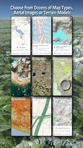
Screenshots


App Description
New: Offroad & Outdoor Navigation. Detailed topographic maps.
Easy to use outdoor navigation app with free access to the best available maps and aerial imagery for Mexico.
Choose between 20+ map layers (topographical maps, aerial imagery, road maps, ...) to plan the perfect trip and
turn your Andoid Phone/Tablet into an outdoor GPS for offline trips into the backcountry.
Add easily maps from other sources (GeoPDF, GeoTiff, Online Map Services like WMS, ...)
Available basemap layers for Mexico:
• INEGI topographical maps 1:20.000 - 1:250.000 ( over 7.000 maps !)
• INEGI digital topographical map
• INEGI digital road map
• INEGI hipsographic map
• USA traditional topographical maps: Seamless coverage of topo maps of the USA at Scales 1:250.000, 1:100.000, 1:63.000 and 1:24.000/25.000
• Topographical maps of Central America 1:50.000 - 1:250.000
Worldwide basemap layers:
• OpenStreetMaps (5 different map layouts), also downloadable in space saving vectorformat
• Google Maps (Satellite images, Road- and Terrain-Map)
• Bing Maps (Satellite images, Road-Map)
• ESRI Maps (Satellite images, Road- and Terrain-Map)
• Earth At Night
• Waze
Configure a basemap layer as an overlay and utilize a transparency fader to seamlessly compare maps with each other.
Add maps from other sources:
• Import raster maps in GeoPDF, GeoTiff, MBTiles or Ozi (Oziexplorer OZF2 & OZF3)
• Add web mapping services as WMS or WMTS/Tileserver
• Import OpenStreetMaps in Vectorformat, eg complete Mexico for just some GBs
Available Mexico map Overlays - add additional information to any other base map:
• Roads
• Railroads
• National Hydrographic Dataset
• Airports
• Geographical names
• Vulcans
• Boundaries
Available worldwide overlays:
• Hillshading overlay
• 20m Contourlines
• OpenSeaMap
There is no perfect map. Toggle between the different map layers or use the compare maps feature to find the most interesting route. Especially the topographical 20k & 50k maps contain many small pathes or other features that are missing on modern digital maps.
Main features for outdoor-navigation:
• Download map data for OFFLINE USAGE
• Measure pathes and aereas
• Create and edit Waypoints
• GoTo-Waypoint-Navigation
• Create and edit Routes
• Route-Navigation (Point-to-Point Navigation)
• Track Recording (with speed, elevation and accuracy profile)
• Tripmaster with fields for odometer, average speed, bearing, elevation, etc.
• GPX/KML/KMZ Import/Export
• Search (placenames, POIs, streets)
• Get elevation and distance
• Customizable datafields in Map View and Tripmaster (e.g. Speed, Distance, Compass, ...)
• Share Waypoints, Tracks or Routes (via eMail, Dropbox, WhatsApp, ..)
• Use coordinates in WGS84, UTM or MGRS/USNG (Military Grid/ US National Grid), What3Words• Track Replay
• and many more ...
Use this navigation app for outdoor activities like hiking, biking, camping, climbing, riding, skiing, canoeing, hunting, snowmobile tours, offroad 4WD tours or search&rescue (SAR).
Add custom waypoints in longitude/latitude, UTM or MGRS/USNG format with WGS84 datum.
Import/Export/Share GPS-Waypoints/Tracks/Routes in GPX or Google Earth KML/KMZ format.
Please send questions, comments and feature requests to support@atlogis.com