AviNavi, navigation for pilots
AviNavi, navigation for pilots Summary
AviNavi, navigation for pilots is a with in-app purchases Android app in Maps And Navigation by Candidus. Released in Mar 2015 (11 years ago). It has about 10.3K+ installs and 25 ratings with a 2.38★ (poor) average. Based on AppGoblin estimates, it reaches roughly 4.00 monthly active users and generates around $<10K monthly revenue (100% IAP / 0% ads). Store metadata: updated Sep 20, 2025.
Recent activity: 2.00 installs this week (2.00 over 4 weeks) showing strong growth View trends →
Store info: Last updated on Google Play on Sep 20, 2025 .
2.38★
Ratings: 25
Screenshots

App Description
VFR and IFR navigation for pilots - CONTINENTAL USA ONLY
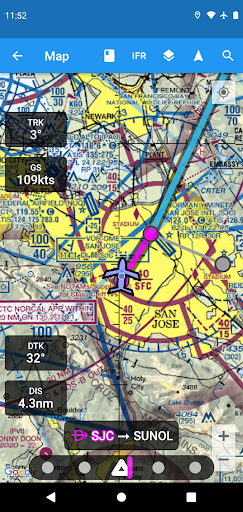
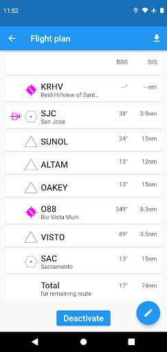
Aviation navigation made simple and affordable. All VFR, low-altitude IFR and instrument approach charts for the continental United States, with full flight planning, including support for airway navigation. Overlays for Nexrad, METARs and AIRMETS/SIGMETS improve flight safety, and detailed airport information (runways, frequencies, fuel, weather) is at your fingertips.
Use the moving map to search or select an airport, VOR, NDB or intersection and start direct-to navigation, or add to the flight plan. Alternatively enter the flight plan in text, e.g. KPAO SUNOL V334 SAC KSAC will load the full flight plan, including all airway navigation points.
Instrument approach charts include the airport diagram, STARS, DPs and minimums, as well as the legend.
Nearby airports are shown in green or red to indicate whether or not those airports are likely reachable in a no-wind glide.
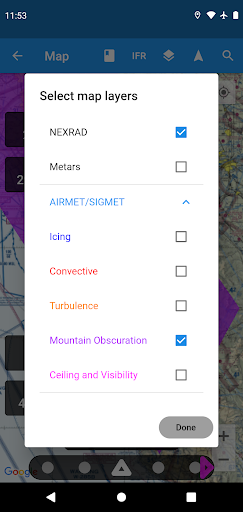
METAR, TAF, AIRMET, SIGMET, Prog charts, Convective Outlook and Wind are available as graphical and/or textual information. METARs and AIRMETS/SIGMETS can be overlayed on the map using the Layers button. Airport information shows METARs and TAFs in plain English, and Prog charts, Convective Outlook and Wind graphics for different times and altitudes are available as full screen graphics.
AviNavi requires a monthly or annual subscription, following a free trial period.