GeoKit: Field Data Collector
GeoKit: Field Data Collector Summary
GeoKit: Field Data Collector is a Android app in the Tools category, developed by AppFlows. First released 8 months ago(Jun 2025), the app has accumulated 666+ total installs
Recent activity: 24 installs this week (151 over 4 weeks) showing below average growth View trends →
Store info: Last updated on Google Play on Jun 1, 2025 .
0★
Ratings:
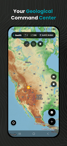
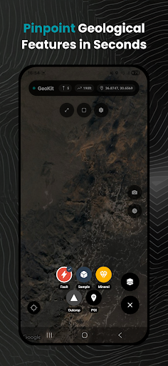
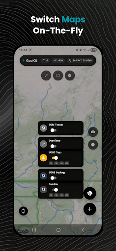
Screenshots
App Description
Geology field data collector: Record GPS samples, map outcrops & export GeoJSON
Transform Fieldwork with GeoKit: The Ultimate Geology Mapping & Data Collection App
GeoKit revolutionizes geological fieldwork, offering a complete toolkit for geologists, volcanologists, and mining professionals. Record precise geological features, measure terrain, visualize critical data layers, and export results seamlessly—all offline in remote environments.
🔍 Key Features
Advanced Geological Markers
Record faults, samples, minerals, outcrops & POIs with custom attributes:
Photo documentation & geotagging
Detailed notes, strike/dip measurements
Mineral composition, rock type classifications
Sample IDs and metadata templates
Professional Mapping Tools
Distance & Area Measurement: Accurately plot boundaries, fault lengths, or mineral zones directly on the map.
Multi-Layer Maps: Switch between geological, topographic, and satellite layers (including USGS, OpenTopoMap).
Real-Time Altitude Tracking: Instantly view elevation data for any location.
Data Management
Export/Import: Support for GeoJSON, KML, GPX, and CSV formats—integrate with GIS software (QGIS, ArcGIS).
Cloud Sync: Securely backup projects and collaborate across teams.
Specialized Geology Tools
Fault Analysis: Log displacement, orientation, and kinematics.
Sample Cataloging: Track locations, weights, and lithology.
Outcrop Mapping: Document stratigraphy and structural features.
Offline Capabilities
Download maps & work without internet—critical for remote mines, volcanoes, or field sites.
🚀 Why Professionals Choose GeoKit
Precision: Military-grade GPS accuracy for reliable data collection.
Efficiency: Cut fieldwork time by 50% with intuitive forms and one-tap exports.
Safety: Terrain analysis and hazard zone mapping for volcanic/earthquake-prone areas.
Compliance: Meet industry standards (JORC, NI 43-101) with auditable data trails.
🎯 Ideal For
Geologists: Mineral exploration, structural mapping, and field surveys.
Volcanologists: Eruption risk assessment and lava flow tracking.
Mining Engineers: Resource estimation and drill site planning.
Academics: Student field trips and research data collection.