 AppGoblin
Earthwork. Volume Measurement
0★
Ratings: 0
Screenshots

App Description
Measuring stockpile - heap, Cut_and_fill, surface editor, (TIN)
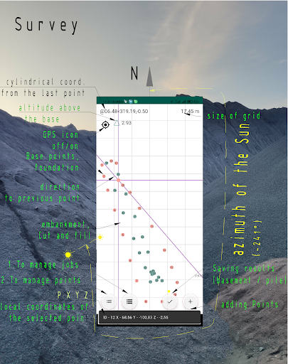
The application Volume Measurement allows you to measure the area, volume of stockpile bounded by a maximum of 500 points connected by straight lines in real time. These points must be measured, or taken from memory, or set via the keyboard. The measured Volume is projected onto an inclined reference plane defined by its points (3D). Volumes embankment are automatically measured by calculating the digital terrain model (DTM) in the local coordinate system, where the first base point is taken as the origin. Triangulations of irregularly distributed points, known as Triangulated Irregular Networks (TIN) allow incorporation of terrain break lines (ridges, valleys), and extreme locations (e.g., summits) to better represent the terrain.
Handy feature:
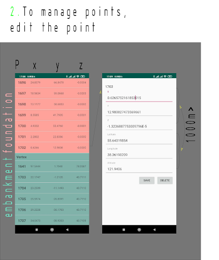
• editing coordinates ( recalculating P, Lat,Lon, H ⇆ P,X,Y,H)
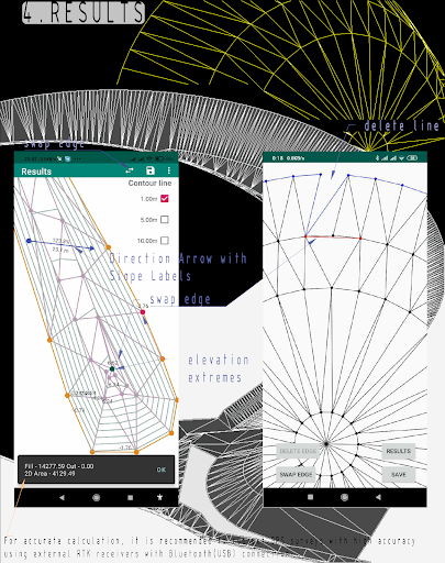
• adding Contour Lines;
• adding Direction Arrow with Slope Labels(Two-point);
• removing duplicate points;
• clipping points that go beyond the base surface;
• calculating the area;
• exporting points to excel (csv);
• export of survey to SVG kml, (https://SVGtoPNG.com +.kml > viewing in google Earth
• cylindrical coordinates (azimuth(θ), distance(r) to the previous point
• exporting the surface to AutoCAD (you just need to drag the script generated by the application from the Explorer to the AutoCAD workspace and automatically draw the surface from _3Dfaces) https://youtu.be/gxceDyb0Bjo;
• adding Contour Lines;
• Inspect surfaces. ▽ +2.93 - dynamic display of the difference between the DTM design elevation and the phone (app) location
• Solar compass. Positioning the receiver (phone screen) by the Sun for easy orientation on the terrain [1] • A Solar compass determines direction using the sun's position, making it immune to magnetic interference (near power lines, metal objects, in magnetic anomaly zones, or during electronic warfare). A magnetic compass loses accuracy near the poles (where magnetic declination can reach tens of degrees) - whereas a solar compass maintains stable operation anywhere with visible sunlight)
Double tap SHIFTS CENTER OF ZOOM - double tap shifts the center of the zoom.
location may use sources like Wi-Fi, mobile networks, and sensors - this reduces the accuracy of measurements - for this reason: settings > location > Google Location Accuracy> Off
While making