Geo Survey - Land Survey
Geo Survey - Land Survey Summary
Geo Survey - Land Survey is a mobile Android app in Maps And Navigation by National Center for Big Data and Cloud Computing. Released in Oct 2020 (5 years ago). It has about 38.4K+ installs and 80 ratings with a 2.60★ (poor) average. Based on AppGoblin estimates, it reaches roughly 1.3K monthly active users . Store metadata: updated Oct 8, 2025.
Recent activity: 119 installs this week (776 over 4 weeks) showing steady growth , and 1.00 new ratings this week View trends →
Store info: Last updated on Google Play on Oct 8, 2025 .
2.6★
Ratings: 80
Screenshots

App Description
Geo survey and data collection
Free application for carrying out GIS survey. This app enables surveyors to collect data (coordinates) of points on a map by creating polygons/poly-lines. This can be done in two ways. First, by walking around the area of interest, or secondly, through manual selection of an area on the map.
Features:
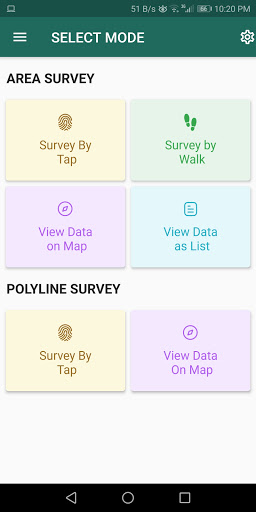
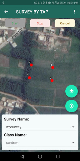
1. Survey can be carried out using any of the two modes:
a. First survey mode (walking mode) can be used by surveyors for collecting several points by walking around the field/land or any region of interest. Polygon will be drawn on the map once survey of field is stopped by the surveyor.
b. Second survey mode (manual selection) can be used by surveyors for collecting several points by tapping on the map. Polygon/poly-line will be drawn on the map once surveyor stops selecting points on the map.
2. Each polygon can be listed under main-category(survey) and subcategory(class) for better organization of survey data.
3. Each polygon can be titled/named separately by surveyor.
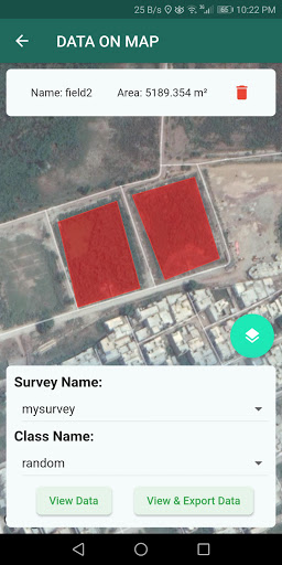
4. Data can be viewed by any of two choices:
a. View data on map - Polygons/poly-lines can be viewed on map by selecting a "survey" name and a "class" name.
b. View data without map - Data of polygons can be viewed without map if user does not want to plot polygons on map and only wants to view data of the polygons.
5. Export and Share - Export and share data in json format.
6. Limit Constraint - This free version of app has a limit constraint of creating 20 polygons/poly-lines for any "class" of any "survey". However, new "classes" can be creating for carrying out survey.
7. Cloud storage - Data is stored in and synced with cloud.