山と高原地図
山と高原地図 Summary
山と高原地図 is a with in-app purchases Android app in Travel And Local by 株式会社昭文社. Released in Feb 2013 (13 years ago). It has about 278.1K+ installs and 658 ratings with a 3.28★ (mixed) average. Based on AppGoblin estimates, it reaches roughly 1.1K monthly active users and generates around $<10K monthly revenue (100% IAP / 0% ads). Store metadata: updated Nov 26, 2025.
Recent activity: 125 installs this week (512 over 4 weeks) showing steady growth View trends →
Data tracking: SDKs and third-party integrations were last analyzed on Apr 20, 2026. The app's network data flows (API traffic to/from the app and its SDKs) were last crawled on Oct 23, 2025.
Store info: Last updated on Google Play on Nov 26, 2025 .
SDKs, Trackers & Permissions
山と高原地図 was last scanned for SDKs 2026-04-20. Below is the overview of third party companies detected in the app. The full list of raw SDKs, app permissions and unknown SDKs is available here.
App Details
App Store
Ads & App-Ads.txt
AppGoblin SDK Scans
3.28★
Ratings: 658
Screenshots


App Description
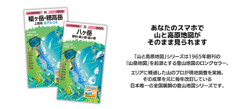
Share No. 1 climbing map "Mountain and Takahara Map" application version First of all, try 'Takao mountain' for free download
■2026 Edition Update Notice■
The 2026 edition maps are now available. (February 20th: 44 areas, March 6th: 19 areas)
When hiking, be sure to update to the latest maps before heading out!
(2026 Edition Map: ¥800 per area)
https://yamachizu.jp/article/16051
■Price
・App itself: Free
・Map per area: ¥800
You can download the "Mount Takao" map for free right now, so please give it a try.
This app is purchased by area.
There is no expiration date for the maps you purchase (this year's edition). However, you will need to purchase new maps (new year's edition) from next year onwards.
You can transfer your purchased maps to a different Android device using the same Google account. Simply re-download them from the "Purchased List" in the app.
Maps cannot be transferred between iPhone and Android devices.
★With our sister app, "Yama to Kogen Chizu Hodai," you can access the latest maps for all areas for a flat rate of ¥500/month or ¥4,800/year. You can also create hiking route plans as a unique feature. Try it free for 7 days.
https://rd.mapple-apps.jp/api/url.php?redid=72
■Key Features
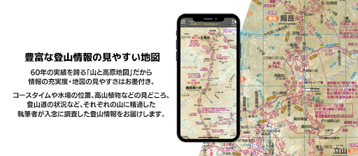
① Easy-to-read maps with abundant hiking information
With 60 years of experience, "Yama to Kogen Chizu" is guaranteed to provide comprehensive information and easy-to-read maps. Our authors, who are experts on each mountain, provide carefully researched hiking information, including course times, water source locations, highlights such as alpine plants, and hiking trail conditions.
② Works even outside of signal range!
All maps are downloaded and saved on your device in advance, so you can use them even in the mountains without signal reception. Using your device in airplane mode saves battery life.
③ Know your current location!
Use GPS to find your location on the "Yama to Kogen Chizu" map for peace of mind.
④ Record your route!
You can not only view your recorded route within the app, but also email it. You can organize your hiking records on your PC or post it to external sites like "Yamareco."
⑤ Covering Japan's 100 Famous Mountains!
All 63 "Mountain and Highland Maps" are now available as apps. This app covers Japan's renowned mountains, from Hokkaido in the north to Yakushima in the south, including all 100 of Japan's famous mountains.
■ Contents
・Includes hiking maps from the "Mountain and Highland Maps" book (surrounding area maps and booklet information are not included). Please see the product details in the app for the included maps.
・Edited for ease of viewing and use on smartphones, such as omitting topographical representations and longitude and latitude lines.
■ Supported OS
・Android OS 4.4 or later (may not work on some devices)
*Cannot be used on devices that are not compatible with the Play Store.
(Raku-Raku Smartphone, Kindle, Fire devices, etc.)
*Current location display and route recording are not available on devices without GPS.
*GPS performance varies greatly depending on the device and operating system.
*It may not work on some devices, so we recommend checking the following after downloading the app and before purchasing the map.
1. Map display: Download and check the free "Mount Takao" map.
2. GPS related: Routes can be recorded even outside the map's range. Display the "Mount Takao" map, record your route, and check whether it can be displayed on a PC or other device like Google Earth. Running this in airplane mode will simulate an environment closer to that of a mountain climber. For instructions on how to send the data to a PC, please refer to the in-app help.
■Note
- Because the data for each area is large (approximately 10-25MB), we recommend downloading over Wi-Fi.
- The background route recording function consumes a significant amount of battery power. To ensure a means of communication in case of an emergency, we recommend setting the app to save battery power (see the in-app help for instructions).
- Always use the app in conjunction with the printed map to protect against battery drain.
- The survey period for published information is listed in the "Notices & Help" > "Credits" section of the app. Due to the nature of the survey, some areas also include information on conditions prior to that time. Furthermore, the conditions of hiking trails and facility opening times in hiking areas can change significantly due to heavy rain, wind, snow, etc., so please make careful decisions and act at your own risk. For safety, be sure to check the situation with local government offices before hiking.
- The information posted is not based on GPS positioning, so it may differ from your actual location. In addition, the accuracy of the location obtained by this app may be reduced depending on the surrounding terrain, etc. Do not rely solely on the location information from this app, but take into account the surrounding terrain and other factors when making your decisions.
- Please note that we cannot be held responsible for any accidents or getting lost.