Wildfire Info
Wildfire Info Summary
Wildfire Info is a with in-app purchases iOS app in Weather by David Gross. Released in Jul 2016 (9 years ago). It has 31 ratings with a 3.42★ (mixed) average. Based on AppGoblin estimates, it reaches roughly 94 monthly active users and generates around $<10K monthly revenue (100% IAP / 0% ads). Store metadata: updated Jan 24, 2025.
Data tracking: SDKs and third-party integrations were last analyzed on Jan 9, 2025.
Store info: Last updated on App Store on Jan 24, 2025 .
3.42★
Ratings: 31
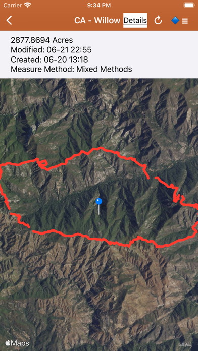
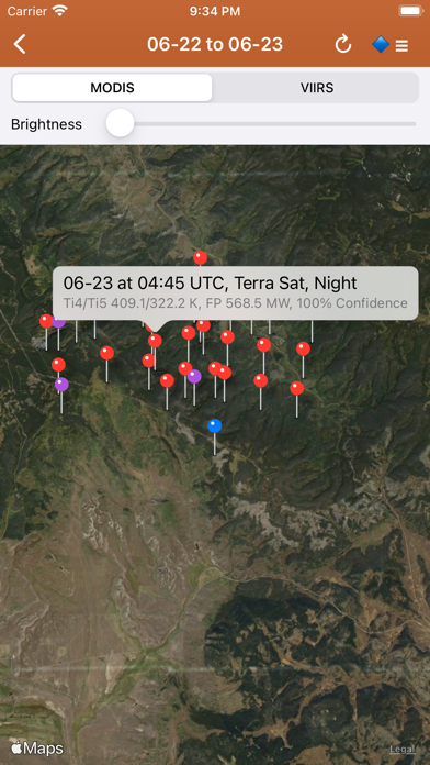
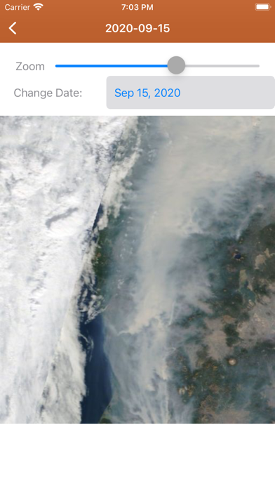
Screenshots


App Description
Disclaimer: This unofficial app does not represent any government agency and is not affiliated with any government agency. The sources of the data are the publicly accessible sources listed below.
Browse current wildfire and prescribed burn activity throughout all of the world.
Active Wildfire Perimeter data from NIFC WFIGS. Tagged by state, search by name, and filter by acres burned. WFIGS stands for the Wildland Fire Interagency Geospatial Services (WFIGS) Group. NIFC stands for the National Interagency Fire Center. NIFC WFIGS Source URLs: https://www.nifc.gov/ with data hosted at https://data-nifc.opendata.arcgis.com/datasets/nifc::wfigs-current-interagency-fire-perimeters/about
NASA MODIS and VIIRS satellite instruments data: Thermal hotspot maps by region show wildfire activity in the past 48 hours. See hotspot info including fire radiance power, brightness temperature, and confidence. NASA MODIS/VIIRS Source URL: https://firms.modaps.eosdis.nasa.gov/active_fire/ . MODIS stands for Moderate Resolution Imaging Spectroradiometer. VIIRS stands for Visible Infrared Imaging Radiometer Suite.
InciWeb & CAL FIRE active fire maps: hot-link to the corresponding official incident webpage. Inciweb Source URL: https://inciweb.wildfire.gov/ , CAL FIRE Source URL: https://www.fire.ca.gov/incidents
CHP (California Highway Patrol): Incidents in the past 3 hours related to fires are filtered out separately, all traffic incidents are included viewable by last 1 or 3 hours.CHP Source URL: https://cad.chp.ca.gov/Traffic.aspx
Lookup current hyper-local weather conditions, including temperature, wind and gust conditions, and local forecasts anywhere in the USA, Canada, or Australia using map quick lookup or, for USA, search: Detailed NWS Forecast, Hourly Forecast, Grid Data Forecast, and Summary Forecast. Data is from the NWS, NOAA, Government of Canada, and Government of Australia. NWS/NOAA Source URL: https://forecast.weather.gov/, Government of Canada Weather Source URL: https://weather.gc.ca/, Government of Australia Weather Source URL: http://www.bom.gov.au/
Wildfire Situation Reports section with mirrored PDFs from NIFC. NIFC Source URL: https://www.nifc.gov
NESDIS GOES 16/17 Satellite Animations show wildfire smoke plumes, drought conditions, etc. from the satellite's perspective. NESDIS GOES Source URL: https://www.star.nesdis.noaa.gov. NESDIS stands for Na