Compass 55. Map & GPS kit.
Compass 55. Map & GPS kit. Summary
Compass 55. Map & GPS kit. is a free, with in-app purchases iOS app in Maps And Navigation by Kalimex-Consulting s.r.o. @Blocoware & Stanislav Dvoychenko. Released in Sep 2016 (9 years ago). It has 5.1K ratings with a 4.69★ (excellent) average. Based on AppGoblin estimates, it reaches roughly 12.9K monthly active users and generates around $<10K monthly revenue (100% IAP / 0% ads). Store last updated Jun 16, 2026
Recent activity: 2.00 new ratings this week View trends →
Compass 55. Map & GPS kit. SDKs Summary
Compass 55. Map & GPS kit. was last scanned for SDKs on 2026-06-28. No known SDKs were detected. Check the raw list of SDK parts detected here and feel free to request unknown SDKs be added to AppGoblin.
4.69★
Ratings: 5.1K
Screenshots
App Description
Compass 55 is an offline-capable GPS map, compass, waypoint, route, and coordinates tool for hiking, off-road travel, field work, aviation, and marine navigation.
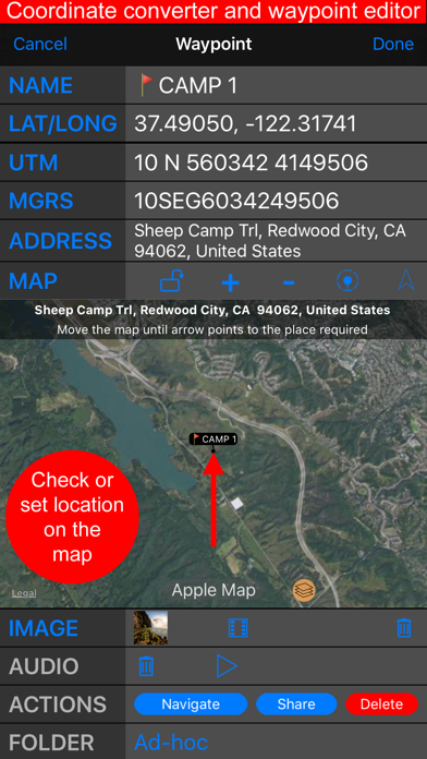
+ Advanced target/waypoint editor. Can be also used as a coordinates converter. You can use map to check or set waypoint location and add photo or audio note.
+ Share your location via email, text message, Facebook or Twitter. This includes UTM, MGRS and Latitude/Longitude (MENU>Share my location).
+ You can use UTM, MGRS or Lat/Long, just pick your preference in settings (Coordinate Format).
+ Speedometer. Shows you the speed and pace. Speedometer also gives you options to control average and max speed and pace counters (MENU > RESET and PAUSE/RESUME counters).
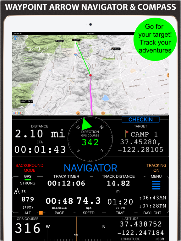
+ Compass. Instant reaction compass, no delays. Automatically pickups the direction based on magnetic or GPS course. If you mostly walk or drive, you can change this automatic mode in app settings > Compass or GPS course. NATO mils? Same place in settings to set.
+ Magnetic declination δ for the current location and any location on the map (via World Magnetic Model, WMM, no need for data/internet).
+ Sunset and sunrise. So you can plan your travel better.
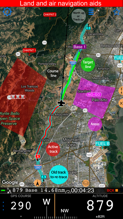
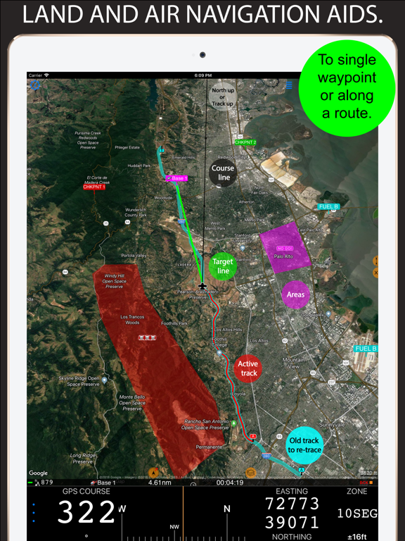
+ Arrow pointing to your target waypoint. Distance and bearing to it.
+ Create/measure routes and areas.
+ Barometric Vertical Speed Indicator (VSI, IVSI) in both scale and graph forms.
+ Integration of bluetooth sensors: Cycling cadence, Heart rate, Cycling speed.
All above belong to a basic version. PRO Pack upgrade will add following capabilities:
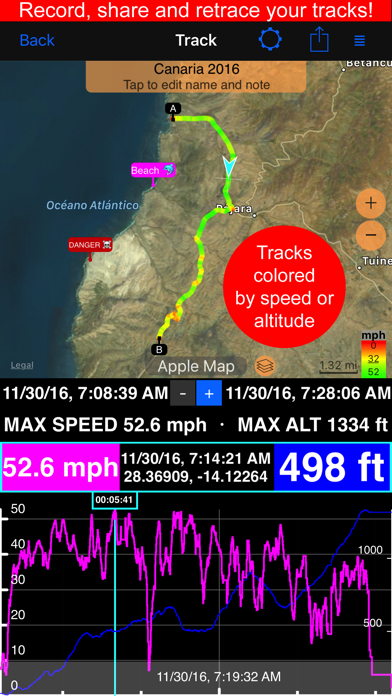
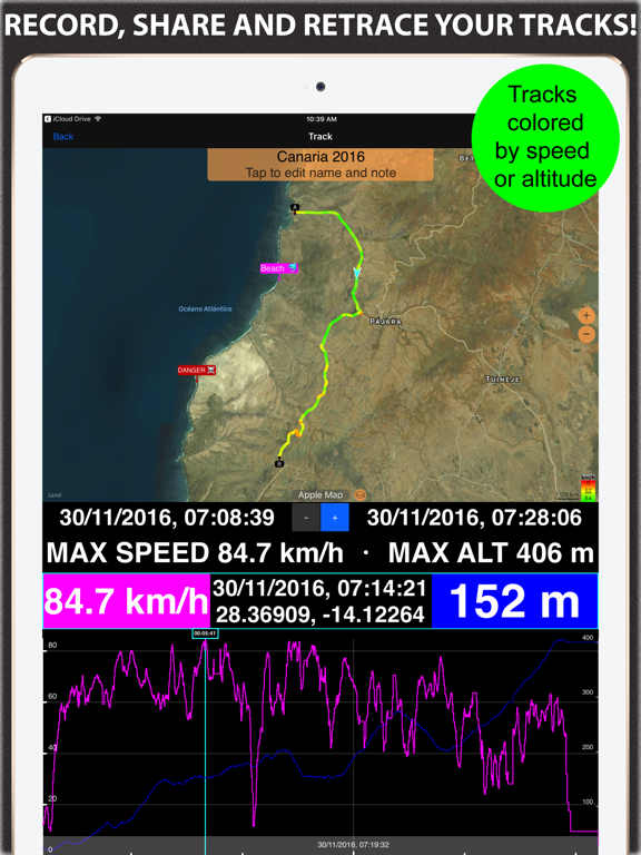
+ Recording and sharing GPS tracks.
+ Moving waypoints between folders.
+ Showing ETA to a target as this requires GPS tracking.
+ Native Google map with fantastic terrain map, amazing 3D and real night mode.
+ Adding own/custom tile map servers.
+ Downloading offline maps. Offline maps import in .sqlitedb, rmaps, mbtiles formats. Support for overzoom and underzoom - offline map is shown even for zoom levels that are not downloaded.
+ GPX import and export for waypoints, tracks and routes.
+ Google Earth KML support for waypoints and tracks import/export. KMZ support for waypoints and tracks export, waypoints import.
+ Ground overlays. Import KMZ ground overlay or draw your own on the map in the app and share as kmz files!
+ CSV import/export for waypoints.
+ Voice coach to tell you active track distance and duration, current speed and al