Ventusky: Weather Forecast
Ventusky: Weather Forecast Summary
Ventusky: Weather Forecast is a with in-app purchases iOS app in Weather by Ventusky s.r.o.. Released in Sep 2017 (8 years ago). It has 43.3K ratings with a 4.80★ (excellent) average. Based on AppGoblin estimates, it reaches roughly 108.3K monthly active users and generates around $<10K monthly revenue (100% IAP / 0% ads). Store last updated Jul 4, 2026
Recent activity: -1 new ratings this week View trends →
SDK intelligence: AppGoblin detected 1 development tools(e.g. Alamofire),and 1 ad networks integrated into Ventusky: Weather Forecast. View full SDK list →
Ventusky: Weather Forecast SDKs Summary
Ventusky: Weather Forecast was last scanned for SDKs on 2026-06-26. Below is the overview of third-party companies detected in the app. The full list of SDKs, permissions and unknowns is available here.
4.8★
Ratings: 43.3K
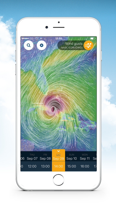
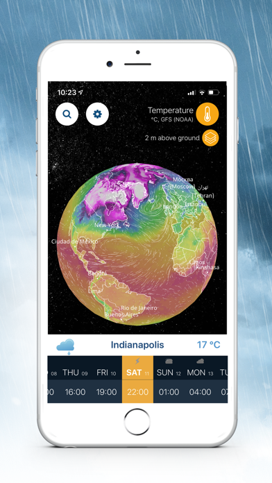
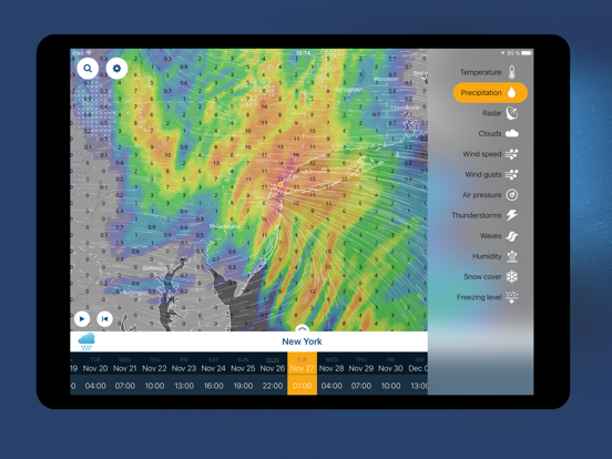
Screenshots


App Description
Ventusky All-in-One Weather is a fusion of 20+ of the world's best models, live radar, satellite and 40,000+ webcams, delivering industry-leading accuracy for planning everything from morning jogs to transatlantic flights.
WE BRING A UNIQUE SET OF FEATURES LIKE:
- Hyperlocal 14-days weather forecast with up to hourly resolution
- 80+ weather maps
- Live radar and lightnings detection
- 40,000+ worldwide webcam coverage
- Lock and home screen widgets with forecasts, webcams, or radar
- Integration with Watch OS
- 3D interactive globe
- Customizable push notifications for: wind, waves, freezing rain, pressure, lightning strikes, umbrella reminder or morning/evening summary.
- Professional features like isolines or weather fronts
- Dual wind animations for 2 different altitudes
- Extensive air quality information
- Hurricane and storm tracking - compare tracks from multiple models and stay safe
Use Ventusky everyday to plan your activities and stay ahead of the weather:
1) Joggers & Outdoor Athletes: Plan with Microscale Precision
For runners, cyclists, and hikers, Ventusky provides updates critical for avoiding sudden weather shifts.
Hyperlocal Wind Gust Maps: Visualize wind speed changes at high resolution, ideal for route planning in mountainous regions.
Lightning Strike Alerts: Receive push notifications for strikes within selected distance, synced to wearable device haptics for hands-free safety.
Feels-Like Temperature: Combines humidity, wind chill, and solar radiation to advise on heatstroke risks during summer runs.
2) Vacation Planners: Verify Conditions in Real Time
Travelers leverage global webcam network and 14-day forecasts to optimize itineraries.
Live Cams: Compare real-time footage from 40K+ coastal, ski resort, and urban cameras to assess conditions before departure.
Tropical Storm Preparedness: Track hurricanes predicting storm paths and landfall in advance.
Air Quality Indexes: Plan trips using SILAM model data on PM2.5, NO2, ozone levels and more.
3) Meteorologists & Professionals: Industrial-Grade Tools
Ventusky serves as a field toolkit for pilots, sailors, and researchers needing altitude-stratified data:
Aviation Wind Layers: Animate wind patterns at 16 altitudes (0m–13km) for flight path optimization.
Marine Forecasting: Access ocean current models and surge predictions for offshore operations.
Agricultural Pl