Outdooractive
Outdooractive Summary
Outdooractive is a free, ad-supported, with in-app purchases iOS app in Travel And Local by Outdooractive AG. Released in Aug 2018 (7 years ago). It has 34.6K ratings with a 4.47★ (good) average. Based on AppGoblin estimates, it reaches roughly 59.1K monthly active users and generates around $<10K monthly revenue (22% IAP / 78% ads). Store last updated Jul 7, 2026
Recent activity: 3.00 new ratings this week View trends →
SDK intelligence: AppGoblin detected 4 development tools(e.g. OpenID), 2 ad networks,and 1 analytics: product integrated into Outdooractive. View full SDK list →
Outdooractive SDKs Summary
Outdooractive was last scanned for SDKs on 2026-06-28. Below is the overview of third-party companies detected in the app. The full list of SDKs, permissions and unknowns is available here.
4.47★
Ratings: 34.6K
Screenshots
App Description
Confidently explore the great outdoors with Outdooractive - Hike and Ride: The most reliable outdoor navigation app, as trusted by thousands of trail wardens, mountain guides and outdoor industry professionals worldwide.
The Outdooractive - Hike and Ride app helps you find officially approved routes near you and around the world, with suggestions for dozens of sports including: hiking paths, trekking trails, mountain biking routes, trail running paths, ski touring routes and more.
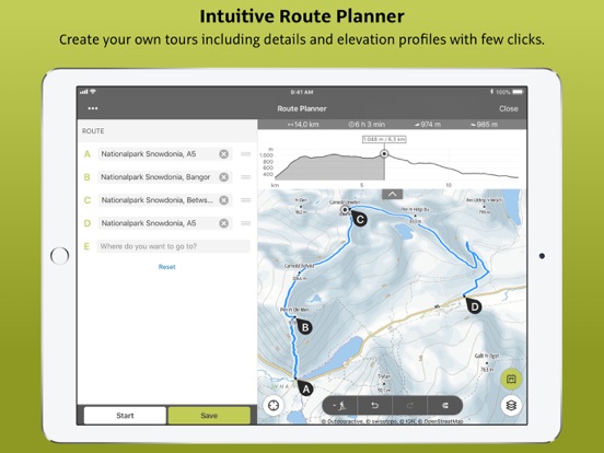
Or plan your own routes using the deepest catalog of official maps to take adventures into your own hands with our map route planner.
Find routes you can rely on: Browse thousands of officially-approved routes near you and across the world, including routes for hiking, road cycling, bike touring, ski touring, gravel riding, trail running, horseback riding, mountaineering and more.
Plan your own routes with tools trusted by professionals: Easily plot your own outdoor routes in the route planner in just a few taps, and see all need to know distance, elevation and terrain info.
Save everything offline: Save individual plans or entire areas offline for reliable navigation when you don't have a phone signal.
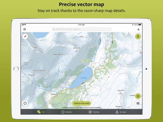
Browse the deepest collection of different map types to track or plan your adventures with confidence: Simply switch between different layers to get a clearer picture of the terrain you're planning to visit, and get the most reliable understanding of conditions on the ground. Outdooractive's map catalog currently includes:
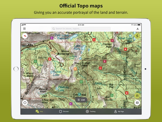
Official topo maps in 25 countries, including:
Ordnance Survey (Landranger & Explorer) in the United Kingdom, New Zealand Land Information in NZ, USGS in the USA, BKG in Germany, BEV in Austria, Swisstopo in Switzerland, IGN in France, PDOK in the Netherlands, Kartverket in Norway, Lantmäteriet in Sweden, Finland National Land Survey in Finland, Harvey Maps in the UK, the official Alpine Club maps for climbing in the Alps
As well as the specially-designed Outdooractive map across France, Germany, Austria and Switzerland.
Share your live location with family and friends: Give yourself and your loved ones complete peace of mind when you're out in the great outdoors thanks to BuddyBeacon.
Join a global community of outdoor tourists and adventurers: Share your activities with the community, join challenges to stay motivated, and get inspired by officiall