Nearest Light
Nearest Light Summary
Nearest Light is a mobile iOS app in Maps And Navigation by Clint O'Connor. Released in Jul 2018 (7 years ago). It has 7.00 ratings with a 3.86★ (average) average. Based on AppGoblin estimates, it reaches roughly 27 monthly active users . Store metadata: updated Jun 7, 2022.
Store info: Last updated on App Store on Jun 7, 2022 .
3.86★
Ratings: 7.00
Screenshots


App Description
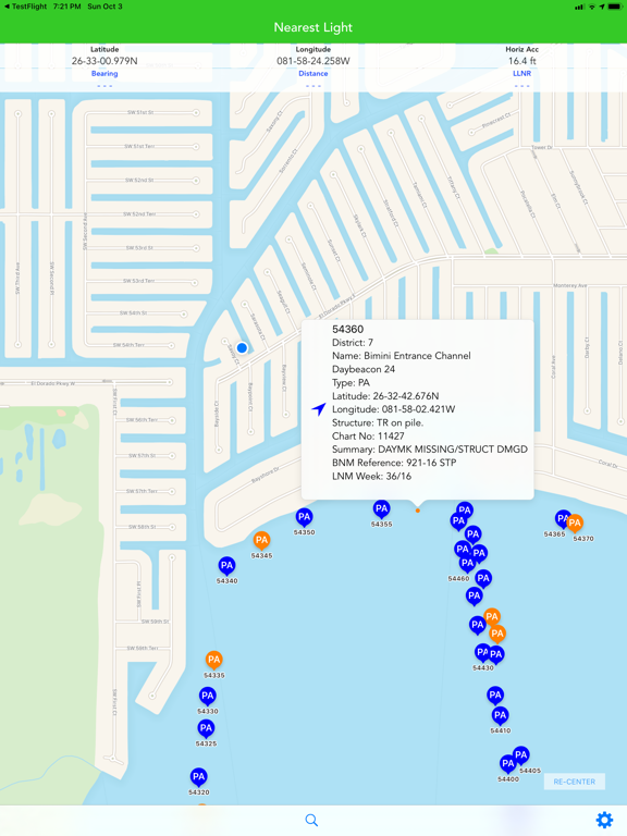
Nearest Light is a informational aid for U.S. waters that shows your location and details on all surrounding aids to navigation (buoys, lights, etc) within your Area of Interest. The app downloads the weekly U.S. Coast Guard Light List for your district, and then shows the aids within your Area of Interest and their details. Any applicable Local Notice for Mariners information is also shown with the light data. Refer to the User Manual (url in Settings) for additional information.
Districts: D1, D5, D7, D8, D8WR, D9, D11, D13, D14, D17
(ref: https://www.navcen.uscg.gov/?pageName=lightLists)
Warning: Nearest Light, which provides Light List data, is not intended to be used in place of charts or Coast Pilots. Charts should be consulted for the location of all aids to navigation. It may be dangerous to use aids to navigation without reference to charts.