GPS Map Camera - Timestamp
GPS Map Camera - Timestamp Summary
GPS Map Camera - Timestamp is a ad-supported, with in-app purchases iOS app in Photo And Video by Jatin Maniya. Released in Jul 2022 (3 years ago). It has 2.7K ratings with a 4.69★ (excellent) average. Based on AppGoblin estimates, it reaches roughly 3.1K monthly active users and generates around $<10K monthly revenue (65% IAP / 35% ads). Store metadata: updated Jun 5, 2026, version 1.
Recent activity: 18 new ratings this week View trends →
Data tracking: SDKs and third-party integrations were last analyzed on Jun 9, 2026.
Store info: Last updated on App Store on Jun 5, 2026 (version 1).
SDKs, Trackers & Permissions
GPS Map Camera - Timestamp was last scanned for SDKs 2026-06-09. Below is the overview of third party companies detected in the app. The full list of raw SDKs, app permissions and unknown SDKs is available here.
AppGoblin saw GPS Map Camera - Timestamp uses 2 Ad Networks
AppGoblin saw GPS Map Camera - Timestamp uses 1 Development Tools
App Details
App Store
Ads & App-Ads.txt
AppGoblin SDK Scans
4.69★
Ratings: 2.7K
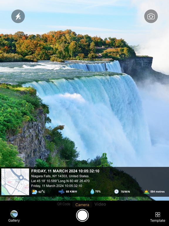
Screenshots


App Description
Capture photo proof with GPS location, date, time, address, coordinates, weather, and map stamp.
GPS Map Camera - Timestamp helps you add accurate location details to your photos in real time. It is useful for work reports, site visits, survey photos, inspection records, travel memories, delivery proof, property documentation, and field activity tracking.
Add Location Details to Photos
Easily capture photos with GPS location, address, latitude, longitude, altitude, date, time, weather, compass, and map stamp. Create location-based photo records whenever you need proof of place and time.
Perfect for Work & Field Use
Use GPS Map Camera for construction sites, real estate visits, field surveys, inspection work, office visits, delivery records, event documentation, and travel photography.
Custom GPS Stamp Templates
Choose from different stamp layouts and customize the information shown on your photos. Add map, address, coordinates, date, time, weather, altitude, compass direction, accuracy, and more.
Manual & Automatic Location
Use automatic GPS location or add location manually when needed. This makes it easy to create geotag photos for both live camera photos and selected gallery photos.
Camera Tools
Capture better photos with useful camera options like grid, ratio, front camera, selfie camera, flash, focus, mirror, timer, zoom, landscape mode, and capture sound support.
Map & Location Options
Customize map type with normal, satellite, terrain, and hybrid views. Add GPS coordinates in different formats and create clear photo records with location watermark.
Useful For:
• Site visits and construction work
• Survey and inspection photos
• Real estate and property documentation
• Travel and outdoor photography
• Delivery and work proof
• Field reports and attendance records
• Events, exhibitions, and business visits
• Bloggers, explorers, engineers, architects, and professionals
With GPS Map Camera - Timestamp, you can turn every photo into a clear record with location, date, time, address, map, and GPS details.
Download now and start capturing geotag photos with GPS timestamp and location stamp.
Privacy Policy: https://chief-cheque-627.notion.site/Privacy-Policy-16f6adfdb37481ab8057d7d27f70aac4
Terms of Use: https://chief-cheque-627.notion.site/Image-To-PDF-16f6adfdb37480caa4b1d57e8911bb43