WeatherTrack GRIB
WeatherTrack GRIB Summary
WeatherTrack GRIB is a with in-app purchases iOS app in Weather by Best Search Infobrokerage, Inc. Released in Feb 2011 (15 years ago). It has 238 ratings with a 4.69★ (excellent) average. Based on AppGoblin estimates, it reaches roughly 705 monthly active users and generates around $<10K monthly revenue (100% IAP / 0% ads). Store metadata: updated Mar 6, 2026.
Recent activity: 2.00 new ratings this week View trends →
Store info: Last updated on App Store on Mar 6, 2026 .
4.69★
Ratings: 238
Screenshots
App Description
WEATHERTRACK
Amazing Weather Details at your Fingertips. Worldwide.
"An incredibly comprehensive weather app - it accesses many data models from different agencies and provides worldwide coverage. The GRIB layers include wind, precipitation, wave height/direction/period, ocean and tidal currents, air and sea temps, relative humidity and more. WeatherTrack works offline, and GRIB files can be downloaded through an SSB connection, an Iridium AxcessPoint or as an email attachment and opened in the app." (App of the month! in Cruisingworld)
http://goo.gl/PLzpI0 (at a glance)
Official partner in the AMERICA's CUP TEAM ARTEMIS (2013)
Forecasts for Professionals and Amateurs...
"Great Tool - I hardly use my SSB radio for weather information any more. Whenever I can pick up Internet via mobile phone, WeatherTrack is much simpler and provides everything that I want."
Everything you could ever want in one app:
+++ GRIB VIEWER FEATURES in DETAIL:
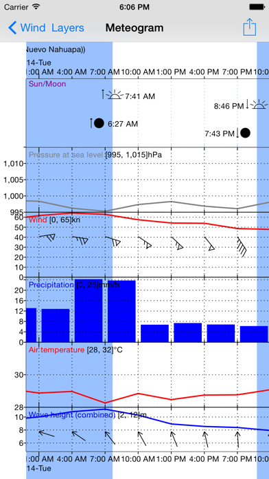
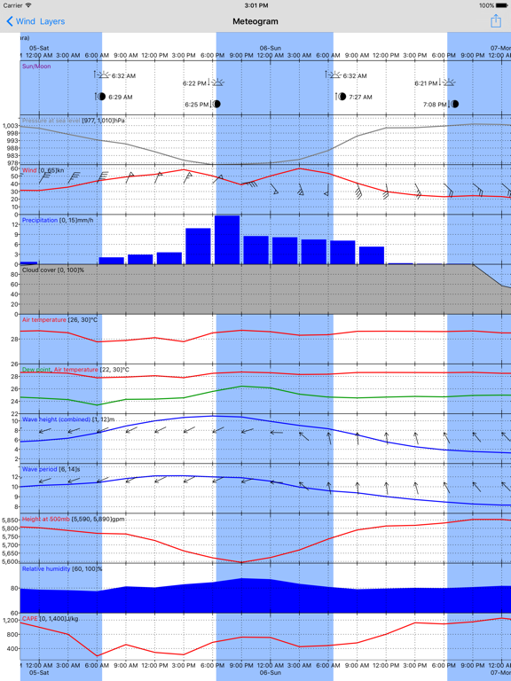
Select area of interest and get detailed GRIB data. View online/offline, point forecast or meteogram (graph).
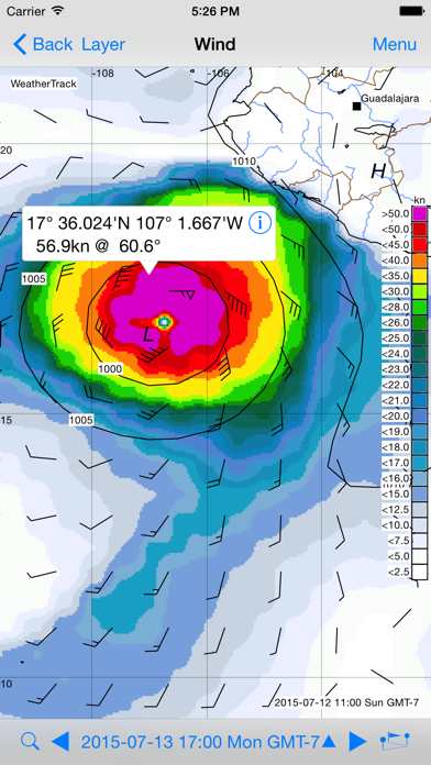
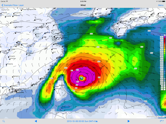
Weather types (GRIB layers):
+ Wind (10 m above MSL)
+ Gusts
+ CAPE
+ Precipitation (rain/snow)
+ Dew point
+ Cloud Cover
+ Waves Height/Direction/Period
+ Ocean current (RTOFS)
+ Barometric Pressure,Highs (H)/Lows (L)
+ Air-/Sea Temperature, Temp. at 500 mb
+ Relative Humidity, Geopot.Height at 500 mb
Forecasts:
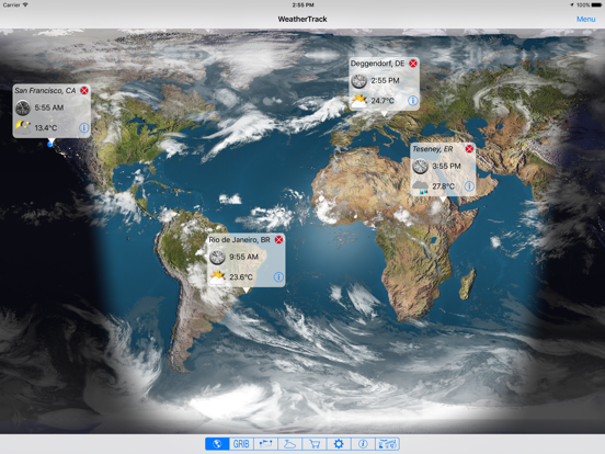
+ Worldwide Coverage
+ Forecasts up to 16 days (depending on data model)
+ Data models:GFS, COAMPS, NAVGEM; current: RTOFS; waves:WW3, WAM85, FNMOC-WW3/FNMOC-MED/FNMOC-EQAM
+ Resolution: 0.05°, 0.5°, 1°, 2°, 2.5° (dep.on data model)
+ Forecast interval: from 15 min up to 24hr (dep.on data model)
+ Updated every 6 hr (GFS)
Map:
+ Offline, high res vector map. Use it offshore or in the mountains.
+ Zoom in - to 0.001° (111 m /121 yd) - (for very high res GRIB files)
+ Customizable
+ Online map (satellite/hybrid/map view)
Specials:
+ Works easily with low bandwith
+ User friendly
+ Meteogram, dynamic, displays any layer
+ Open GRIB files from Email/Browser, 3rd party
+ Share (Twitter, Facebook, email)
+ City/Airport Search
+ Magnifier
+ In-app guide (offline)
+ Animation - watch & share
+ Import/export GRIB files to and from your PC
+ GRIB via Iridium access point
+++ ROUTE WEATHER
helps you plan your trip well (In-App purchase).
http://goo.gl/PXFCIj (at a glance)
+ Create your own route. Im