Speedometer 55 Pro. GPS kit.
Speedometer 55 Pro. GPS kit. Summary
Speedometer 55 Pro. GPS kit. is a with in-app purchases iOS app in Maps And Navigation by Stanislav Dvoychenko. Released in Jun 2012 (14 years ago). It has 6.8K ratings with a 4.68★ (excellent) average. Based on AppGoblin estimates, it reaches roughly 17K monthly active users and generates around $<10K monthly revenue (100% IAP / 0% ads). Store last updated Jul 5, 2026
Recent activity: 6.00 new ratings this week View trends →
Speedometer 55 Pro. GPS kit. SDKs Summary
App not yet scanned for SDKs.
4.68★
Ratings: 6.8K
Screenshots


App Description
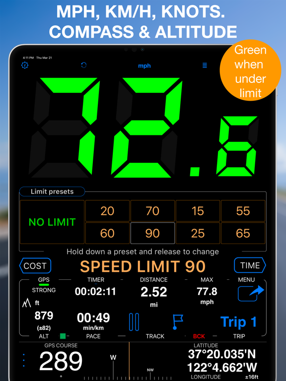
A premium speedometer, GPS tracker, and trip cost monitor for iPhone and cellular iPad. Stay informed and in control while you drive. When you exceed a preset speed limit, the large digits turn from green to red with a sound alert. Track trip costs in real-time and split expenses with passengers. Record your trips for easy review, analysis, or sharing.
Features:
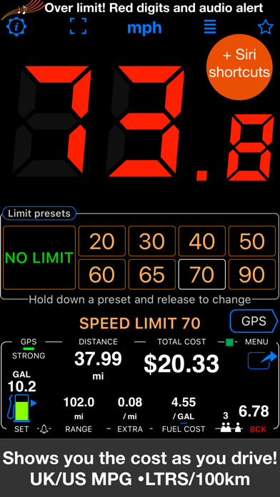
■ Cost & Fuel Monitor
Monitor your driving costs in real-time. Enter fuel price and efficiency (US/UK MPG or L/100 km), plus optional extra charges per mile or kilometer. Ideal for cost-conscious drivers and fare splitting. Includes a fuel monitor and range alerts — helpful if your fuel gauge is unreliable.
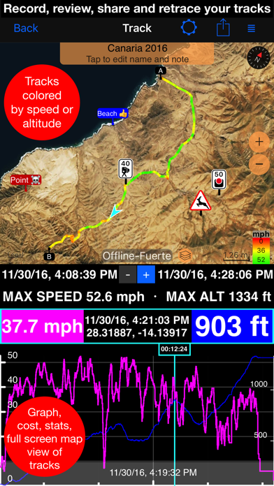
■ GPS Tracking
Keep detailed track of your mileage! Start GPS track recording via MENU > NEW TRACK and stop it with MENU > STOP TRACK. You can re-trace previously recorded tracks by adding them back to the map. Export/import tracks in GPX, KML, or KMZ formats.
■ Mileage Calculator
Pre-calculate distance, fuel costs, and mileage between addresses. Save the route as a track or a set of trips for specific days and times. Useful for filling gaps in mileage logs.
■ PDF Mileage Reports
Convert mileage and trip data into customizable, professional reimbursement reports.
■ Speed Limits & Memory
Set speed limits with 4 or 8 one-tap presets. The app can optionally remember where each limit was used and re-apply them automatically.
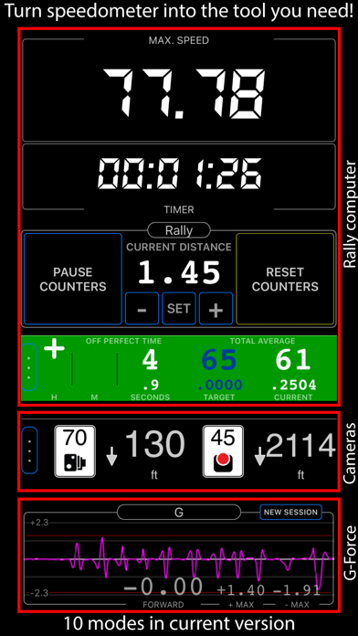
■ Modes (MENU > MODES)
• Default (speed + trip computer)
• Full-screen speed display (huge digits in landscape)
• Mirrored heads-up display (HUD) for windshield reflection
• Rally computer
• G-Force monitor
• Camera and waypoint alerter
• Taximeter
• Map display and full-screen map
• Water sports mode (includes sunset countdown and alert)
• Idle timer mode (alerts when idling)
• Paragliding mode (barometric speed and altitude)
• Land, air, and marine navigation (with directional arrow to a target waypoint or along route)
■ Waypoints
With optional photo or audio recording. Alert on approach or apply speed limit. Export/import in CSV, GPX, KML, KMZ formats.
■ Red Light & Speed Cameras
Import camera data or use the built-in library. Alerts you on camera approach and auto-sets speed limits.
■ Barometric VSI
Displays real-time vertical speed based on barometric data.
■ Barometric Altimeter
Supports QFE/QNH settings.