Singapore MRT Map Route 新加坡地铁
Singapore MRT Map Route 新加坡地铁 Summary
Singapore MRT Map Route 新加坡地铁 is a with in-app purchases iOS app in Maps And Navigation by Wan Peng. Released in Jun 2012 (13 years ago). It has 5.7K ratings with a 4.57★ (excellent) average. Based on AppGoblin estimates, it reaches roughly 22.4K monthly active users and generates around $<10K monthly revenue (100% IAP / 0% ads). Store metadata: updated May 20, 2026.
Recent activity: 56 new ratings this week View trends →
Data tracking: SDKs and third-party integrations were last analyzed on Feb 11, 2025.
Store info: Last updated on App Store on May 20, 2026 .
4.57★
Ratings: 5.7K
Screenshots


App Description
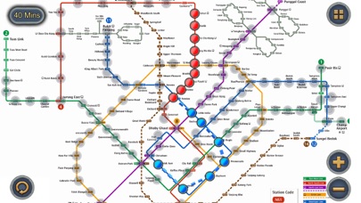
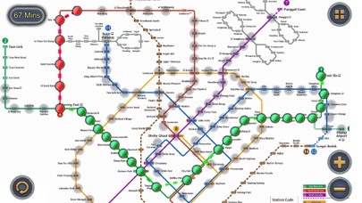
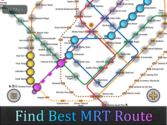
Singapore MRT Map Route is designed to allows user to get the best route within a second.
- View the lastest subway map
- Caculate the best route between two stations
- Display estimated travel time
Updated to latest subway system:
North-South Line (NSL)
Jurong East, Bukit Batok, Bukit Gombak, Choa Chu Kang, Yew Tee, Kranji, Marsiling, Woodlands, Admiralty, Sembawang, Canberra, Yishun, Khatib, Yio Chu Kang, Ang Mo Kio, Bishan, Braddell, Toa Payoh, Novena, Newton, Orchard, Somerset, Dhoby Ghaut, City Hall, Raffles Place, Marina Bay, Marina South Pier
East-West Line (EWL)
Tuas Link, Tuas West Road, Tuas Crescent, Gul Circle, Joo Koon, Pioneer, Boon Lay, Lakeside, Chinese Garden, Jurong East, Clementi, Dover, Buona Vista, Commonwealth, Queenstown, Redhill, Tiong Bahru, Outram Park, Tanjong Pagar, Raffles Place, City Hall, Bugis, Lavender, Kallang, Aljunied, Paya Lebar, Eunos, Kembangan, Bedok, Tanah Merah, Simei, Tampines, Pasir Ris
(Changi Airport Branch from Tanah Merah)
Expo, Changi Airport
North East Line (NEL)
HarbourFront, Outram Park, Chinatown, Clarke Quay, Dhoby Ghaut, Little India, Farrer Park, Boon Keng, Potong Pasir, Woodleigh, Serangoon, Kovan, Hougang, Buangkok, Sengkang, Punggol
Circle Line (CCL)
Dhoby Ghaut, Bras Basah, Esplanade, Promenade, Nicoll Highway, Stadium, Mountbatten, Dakota, Paya Lebar, MacPherson, Tai Seng, Bartley, Serangoon, Lorong Chuan, Bishan, Marymount, Caldecott, Botanic Gardens, Farrer Road, Holland Village, Buona Vista, one-north, Kent Ridge, Haw Par Villa, Pasir Panjang, Labrador Park, Telok Blangah, HarbourFront
(Marina Bay Branch from Promenade)
Bayfront, Marina Bay
Downtown Line (DTL)
Bukit Panjang, Cashew, Hillview, Beauty World, King Albert Park, Sixth Avenue, Tan Kah Kee, Botanic Gardens, Stevens, Newton, Little India, Rochor, Bugis, Promenade, Bayfront, Downtown, Telok Ayer, Chinatown, Fort Canning, Bencoolen, Jalan Besar, Bendemeer, Geylang Bahru, Mattar, MacPherson, Ubi, Kaki Bukit, Bedok North, Bedok Reservoir, Tampines West, Tampines, Tampines East, Upper Changi, Expo
Thomson-East Coast Line (TEL)
Woodlands North, Woodlands, Woodlands South, Springleaf, Lentor, Mayflower, Bright Hill, Upper Thomson, Caldecott, Stevens, Napier, Orchard Boulevard, Orchard, Great World, Havelock, Outram Park, Maxwell, Shenton Way, Marina Bay, Marina South, Gardens by the Bay
南北线 (North-South Line)
裕廊东, 武吉