coolAltitude
coolAltitude Summary
coolAltitude is a with in-app purchases iOS app in Maps And Navigation by SilkIdea s.r.o.. Released in May 2013 (13 years ago). It has 9.00 ratings with a 4.88★ (excellent) average. Based on AppGoblin estimates, it reaches roughly 17 monthly active users and generates around $<10K monthly revenue (100% IAP / 0% ads). Store metadata: updated Jan 20, 2026.
Store info: Last updated on App Store on Jan 20, 2026 .
4.88★
Ratings: 9.00
Screenshots


App Description
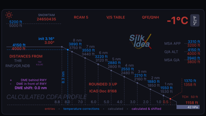
coolAltitude is a professional support tool for IFR pilots operating in cold-weather conditions.
It assists with temperature corrections during instrument approaches and integrates weather, runway and de-/anti-icing data into a single, clear workflow.
Designed to reduce workload and improve situational awareness during flight preparation, coolAltitude focuses on accuracy, clarity and operational usability.
Some advanced features require a paid subscription.
--------------------------------
What coolAltitude does
• Calculates temperature-corrected altitudes for ILS (CAT I), RNAV/GNSS, VOR and NDB approaches
• Requires minimal data entry, using consistent color coding for immediate interpretation
• Displays corrected altitudes along the entire approach profile at relevant DME distances
• Supports flight path angle (FPA) calculations for FPA-enabled aircraft
• Provides vertical speed reference tables (corrected and uncorrected) for various ground speeds
• Includes QNH to QFE conversion tables with temperature corrections
--------------------------------
Integrated weather and runway information
• Live METAR interaction with automatic propagation of relevant values, including temperature (requires subscription)
• SNOWTAM decoding with braking action information
• RCAM (Runway Condition Assessment Matrix) based on ICAO GRF
• Support for DME shift, including threshold, touchdown zone and displaced DME references
--------------------------------
De-/Anti-icing support (requires subscription)
• FAA Holdover Time (HOT) Guidelines for multiple fluid types and manufacturers
• Integrated HOT countdown timer to track minimum and maximum recommended holdover times
• Reference tables supporting assessment of snowfall intensity
• Structured storage and sharing of airport-specific de-/anti-icing procedures
--------------------------------
Saved and shared data (requires subscription)
• Save and reload approach presets for individual airports and procedures
• Share verified, structured operational data with other users
• Local override of shared data when required
--------------------------------
Built for professional use
coolAltitude is built by pilots, for pilots.
It is designed to support decision-making during high-workload phases without replacing approved procedures.
--------------------------------
Important notice