GPX viewer 2
GPX viewer 2 Summary
GPX viewer 2 is a with in-app purchases iOS app in Maps And Navigation by Jonathan Gander. Released in Jan 2023 (3 years ago). It has 17 ratings with a 4.24★ (good) average. Based on AppGoblin estimates, it reaches roughly 44 monthly active users and generates around $<10K monthly revenue (100% IAP / 0% ads). Store metadata: updated Feb 21, 2026, version 73.
Data tracking: SDKs and third-party integrations were last analyzed on Feb 27, 2026.
Store info: Last updated on App Store on Feb 21, 2026 (version 73).
4.24★
Ratings: 17
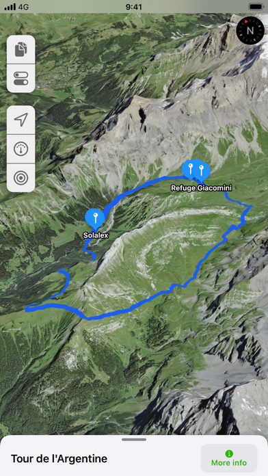
Screenshots


App Description
GPX viewer 2 is the brand new version of my first GPX viewer app! With new features, a new modern user interface and new interactions. I've listened to your needs and built a new app just for you!
Import your tracks from GPX files (tracks or routes) into the app. Even if your file contains many tracks.
Display their tracks on different preset base maps (plan, satellite, OpenStreetMap, OpenTopoMap, Swisstopo, IGN) or on any of your own custom base maps.
Display an interactive elevation profile to evaluate track difficulty. And check out all of information contained into your GPX file (such as description, images, links, waypoints and stats).
Track your position along the route during your hike by following the path on the interactive map. You can also view GPX points of interest, navigation tools (compass, GPS location, altitude) and a speedometer. The app even provides weather conditions at the starting point of your itinerary.
All what you need to go hiking and follow your route... without ads! The only in-app purchases are tips for few other features, just take a look.
GPX viewer is the app you need for your hikes and bike or motorcycle trips!
Features details:
- Import of GPX files via file, web link or from your Fitness app
- Management of imported GPX (library)
- Display GPX track on the map (track and route, also support multi-tracks)
- Several base maps: map, hybrid, satellite 3D, OpenStreetMap, OpenTopoMap, Swisstopo
- Possibility to set your own custom maps from a library or manually
- Possibility to download maps for offline use
- Displayed on the map: current position, start and end of the route, points of interest along the route, scale, route direction
- Choice of color and size of the route
- Color of waypoints's markers
- Locking of screen standby to better follow the route
- Larger interface for cycling and motorcycling
- Rain mode to prevent the interface from being activated when it’s raining
- Map cache system
- Display of GPX details: name, description, elevation profile, elevation differences, distance, altitudes, image gallery, link, points of interest, duration
- Display details of a point of interest: name, description, image gallery, links, distance on the track
- Support for audio links as an audio guide (on GPX and Waypoints)
- Navigation tools: compass, GPS location, altitude
- Weather condition at starting point
- Access