GPSCam : Live Geotag on Photos
GPSCam : Live Geotag on Photos Summary
GPSCam : Live Geotag on Photos is a mobile iOS app in Business by Amiben Kevadiya. Released in May 2024 (2 years ago). It has 11 ratings with a 4.54★ (excellent) average. Based on AppGoblin estimates, it reaches roughly 73 monthly active users . Store metadata: updated May 30, 2024.
Store info: Last updated on App Store on May 30, 2024 .
4.54★
Ratings: 11
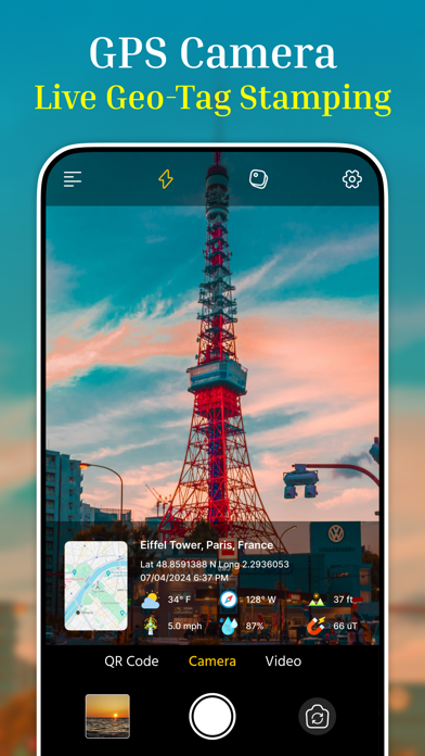
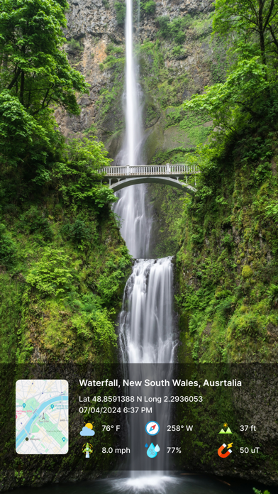
Screenshots

App Description
Why Choose GPSCam?
With GPSCam, every photo tells a complete story. Whether you're scaling a mountain, attending a special event, or documenting a construction site, GPSCam ensures your photos are enriched with all the relevant details. Easy to use and highly customizable, it's the perfect tool for anyone who values precision and detail in their photography.
Make every photo you take a vivid memory with GPSCam, the ultimate app for adding live geotags to your pictures. Designed for adventurers, travelers, and anyone who loves documenting their experiences, GPSCam enriches your photos with detailed location data, timestamps, weather conditions, and more.
----Key Features----
• Automatic or Manual Map Data: Easily add GPS location stamps and timestamps to your photos.
• Custom Camera Settings: Utilize grid, ratio, front & selfie camera, flash, focus, mirror, timer, and capture sound support for perfect shots.
• Flexible Templates: Personalize your geotags with various map types (Normal, Satellite, Terrain, Hybrid), manual or automatic addresses, GPS coordinates (DMS and Decimal), date & time formats, and weather details (Fahrenheit or Celsius).
• Comprehensive Data Tags: Include additional information like wind speed, compass direction, magnetic field, pressure, humidity, altitude, and accuracy on your images.
----Secure Your Memories----
• Google Drive Photo Backup: Automatically back up your photos to Google Drive to ensure your precious moments are always safe and accessible.
----Perfect For----
• Adventurers: Trekkers, explorers, and archaeologists who need precise location data for their expeditions.
• Professionals: Civil engineers, architects, and infrastructure inspectors who document site visits.
• Event Organizers: Capture the essence of fashion shows, weddings, anniversaries, and festivals with detailed geotags.
• Bloggers: Travel, food, fashion, and art bloggers who want to enhance their storytelling with accurate location data.
How GPSCam Enhances Your Photography
• Real-Time Geotagging: Capture the exact location, date, and time of your photos instantly.
• Environmental Context: Add weather conditions, altitude, and other details to give more context to your images.
• Professional Utility: Perfect for site documentation, ensuring all necessary data is recorded and visible on each photo.
• Personal & Social Sharing: