AirBear: Offline Map & Track

AirBear: Offline Map & Track Summary
AirBear: Offline Map & Track is a free iOS app in Productivity by ACGAO. Released in Jan 2026 (8 months ago). It has 1.00 ratings with a 5.00★ (excellent) average. Based on AppGoblin estimates, it reaches roughly 5.00 monthly active users . Store last updated Jan 15, 2026
AirBear: Offline Map & Track SDKs Summary
App not yet scanned for SDKs.
5★
Ratings: 1.00
Screenshots


App Description
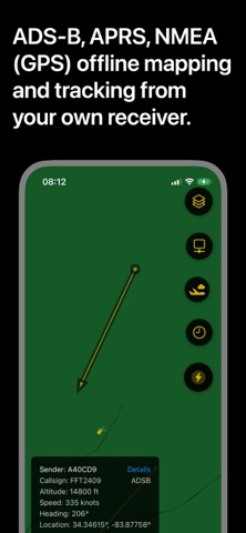
AirBear is the exciting new app for iPhone, iPad and Mac that enables fully offline, on-the-go tracking and mapping of APRS (HAM Radio), ADS-B (airplanes) and NMEA-0183 (GPS). AirBear comes preloaded with worldwide political boundaries, major highways and high resolution taxiways and runways for 1,000s of airports.
AirBear is designed to integrate with 3rd party utilities that you manage, such as Dire Wolf (for ADS-B) and Dump1090 (for APRS). AirBear also directly supports NMEA-0183 output delivered via a TCP connection.
For fully off-grid operation, AirBear can communicate with your receiver -- such as a Raspberry-Pi -- via Bluetooth Low Energy (BLE), removing the need for ethernet or wifi.
AirBear includes setup and configuration instructions. It only takes a moment to get up-and-running after your receiver is configured.