Geo Tag Photo & Map Camera

Geo Tag Photo & Map Camera Summary
Geo Tag Photo & Map Camera is a free, ad-supported, with in-app purchases iOS app in Photo And Video by Dinh Kim Ngan. Released in Feb 2026 (8 months ago). It has 2.00 ratings with a 5.00★ (excellent) average. Based on AppGoblin estimates, it reaches roughly 4.00 monthly active users and generates around $<10K monthly revenue (27% IAP / 73% ads). Store last updated Oct 23, 2026
Geo Tag Photo & Map Camera SDKs Summary
App not yet scanned for SDKs.
5★
Ratings: 2.00
Screenshots




App Description
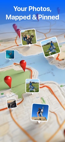
GPS Map Camera turns your iPhone into a geotagging camera that adds GPS coordinates, map overlay, date & time, and address stamps on photos and videos, plus current weather on supported templates — every moment becomes a memory with location proof.
Key Features
- Auto embed GPS coordinates & map overlay on photos & videos.
- Add date & time stamps instantly as you shoot.
- Customizable stamp templates & styles.
- Altitude, compass & coordinates display.
- Measure land area and perimeter on the map.
- Share geotagged images on social or cloud.
- Weather on stamps: the "Report · Weather", "GPS 9 · Weather" and "DateTime - Weekday · Weather" templates show the current temperature and weather icon from Apple Weather (internet required). Choose °C or °F, and turn Weather on or off for any stamp in Edit Template.
- Find Route: plan a driving or walking route from A to B on the map, with step-by-step directions. Open it from the Menu.
Why You’ll Love It
- Perfect for travel memories, field documentation, delivery proof, real estate photos, construction site logs.
- Powerful but easy - no manual editing needed.
- Works offline with GPS lock and location accuracy (weather and Find Route need an internet connection).
- Weather data: Apple Weather.
Legal Information:
Privacy Policy:
https://mobocovietnam.com/Privacy-policy.html
Terms of Use:
https://mobocovietnam.com/Term-of-Use.html
Apple Standard EULA:
https://www.apple.com/legal/internet-services/itunes/dev/stdeula/