Place: Explore the Outdoors

Place: Explore the Outdoors Summary
Place: Explore the Outdoors is a free, with in-app purchases iOS app in Books And Reference by MARTY RADD ICENOGGLE. Released in Jul 2026 (2 months ago). Store last updated Sep 20, 2026
Place: Explore the Outdoors SDKs Summary
App not yet scanned for SDKs.
0★
Ratings: 0
Screenshots



App Description
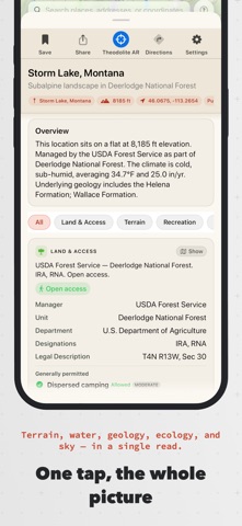
Place turns any location into a rich, human-readable field report — instantly. Tap the map, search by name, or use where you're standing. Place assembles terrain, geology, hydrology, land ownership, ecology, weather and hazards into a profile you can actually read in the field.
UNDERSTAND ANY LOCATION
64 report sections from authoritative public data — USGS, NOAA, BLM, the Forest Service, FEMA, iNaturalist and dozens more. Terrain, bedrock geology, the watershed and stream network, land status, ecoregion, climate, and nearby species. New installs get a one-minute guided tour.
GEOLOGY & DEEP TIME
The bedrock beneath you in plain language, the region's rock layers oldest to youngest, and a story of how this ground came to be. Plus named landforms, glaciers, and what lived here in deep time.
WATER
Follow a raindrop from where you tapped, river by river, to the sea. Streamflow and snowpack from the nearest gauges, the river's gradient, tributaries and waterfalls.
LAND OWNERSHIP & PARCELS
Who owns and manages the ground — federal, state, tribal or private — with the managing unit, designations, what's generally permitted, agency alerts, and the legal township/range description. In 28 states Place identifies the tax parcel under your finger; in 18 of those it names the owner of record. Seven draw tappable parcel boundaries. Dispersed camping answers on BLM, National Forest, state trust and tribal land, each state's rule quoted from its agency.
HUNTING & FISHING
Districts, season dates, bag limits and access for all 50 states, DC and the territories — checked against each agency's own published rules and re-checked weekly, with the agency named and linked on every card. In 154 national park units the park's own rule leads, quoted from nps.gov. Hunting-district overlays by species, fishing districts, access and closure pins.
HAZARDS, FREE FOR EVERYONE
National Weather Service watches and warnings, avalanche danger, earthquakes, drought, burn severity, tsunami runups, smoke, and conditions from the nearest station. Answers with a safety consequence are free on every plan — and where nobody forecasts, Place says so rather than implying it's safe.
MAP OVERLAYS
USGS topo, satellite, BLM surface management, federal land, hunting and fishing districts, geology, biodiversity, parcels, floodplains, trails, mountain bike trails, whitewater, weather radar,