Missoula Ice Age Floods

Missoula Ice Age Floods Summary
Missoula Ice Age Floods is a free iOS app in Education by MARTY RADD ICENOGGLE. Released in Jun 2026 (3 months ago). It has 1.00 ratings with a 5.00★ (excellent) average. Based on AppGoblin estimates, it reaches roughly 5.00 monthly active users . Store last updated Jun 23, 2026
Missoula Ice Age Floods SDKs Summary
App not yet scanned for SDKs.
5★
Ratings: 1.00
Screenshots




App Description
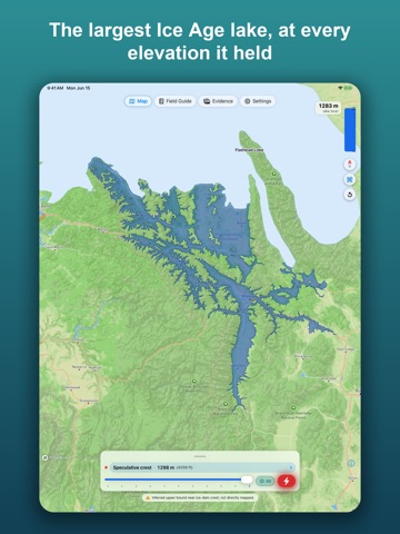
About 15,000 years ago, an ice dam across the Clark Fork in northern Idaho impounded a 2,000-square-mile lake that periodically broke loose and rewrote the Pacific Northwest. Missoula Ice Age Floods lets you watch that lake fill, drain, and reshape the landscape — directly on the map, at the elevations the geologic record actually supports.
WHAT YOU CAN DO
• Slide through eleven reconstructed lake stands, from a low 850 m drainage threshold up to the 1,265 m maximum stand. Watch the shoreline trace real contours across western Montana and northern Idaho — the polygons are computed from USGS 10-meter elevation data, not painted by hand.
• Trigger the dam-break cinematic and watch a seven-phase outburst flood unfold: ice-dam failure, the initial surge through the Purcell Trench, the convergence at Wallula Gap, scabland scouring on the Columbia Plateau, fan deposition in the Pasco Basin, and the rhythmite-forming backwater in the Willamette Valley.
• Read the discharge in real time. A speedometer shows peak flows in cubic meters per second and CFS; a hydrograph translates those numbers into "Amazon Rivers" so the scale is intuitive. The lake-level bar drains as the volume leaves.
• Tap any reconstructed stand for a deep-dive card with the evidence, the confidence level, and the primary literature.
• Browse the Evidence Gallery — giant current ripples at Camas Prairie, the rhythmite sections in the Walla Walla and Willamette Valleys, the Wallula Gap constriction, the high-water tide-line on the surrounding mountains. Tap "Show on map" to fly the camera straight to the location.
• Use the Field Guide for Levels, Dam-break phases, Drainage thresholds, and Sources. Every "Show on map" jumps the simulator to that exact configuration.
• Tilt to 3D for terrain-shaded relief, or stay flat for the cartographic read.
WHAT THIS APP IS NOT
This is an interpretive scientific visualization, not a survey-grade reconstruction. Paleo-lake elevations carry uncertainty; the slider snaps onto reconstructed stands, not arbitrary numbers. Every confidence label, citation, and caveat in the app reflects the current peer-reviewed literature. We've cited Pardee, Bretz, Baker, Waitt, O'Connor, Atwater, Smith, and many others — the bibliography is in Settings → Primary sources.
PRIVACY
No accounts. No analytics. No ads. The app does not collect persona