Spotter Tools Pro: Storm Radar

Spotter Tools Pro: Storm Radar Summary
Spotter Tools Pro: Storm Radar is a mobile iOS app in Weather by DUSTIN GARNER101822321601. Released in Jun 2026 (4 months ago). It has 7.00 ratings with a 5.00★ (excellent) average. Based on AppGoblin estimates, it reaches roughly 60 monthly active users . Store last updated Oct 11, 2026
Recent activity: 1.00 new ratings this week View trends →
Spotter Tools Pro: Storm Radar SDKs Summary
App not yet scanned for SDKs.
5★
Ratings: 7.00
Screenshots




App Description
Spotter Tools Pro is a severe weather app for weather enthusiasts, storm chasers, and trained spotters. GPU-rendered NEXRAD radar, turn-by-turn directions, live wind flow, soundings, lightning, satellite, worldwide tropical, air quality, five forecast models, IBW alerts, live chasers, and thousands of live cameras. Plus Spotter Network reporting and Chaser Mode. Buy once. No subscription, no ads, no third-party trackers.
TURN-BY-TURN DIRECTIONS
Drive to any address, town, or map point with your route drawn over live radar and warnings. Turn banner with distance and arrival time, spoken prompts that lower your music, and automatic rerouting. Start from search or a long-press.
SPOTTER NETWORK REPORTING & BEACON
Tornado, funnel cloud, wall cloud, hail, measured wind, flood, flash flood, and damage, each with the exact fields Spotter Network expects. Reports queue offline and auto-upload. Foreground and background GPS beacon with a configurable interval.
RADAR: LEVEL 2, LEVEL III & TDWR
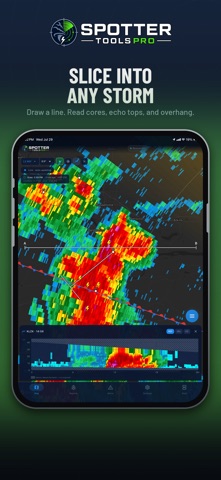
Crisp at any zoom. Single-site Level 2 decoded on-device: Reflectivity, Velocity, Correlation Coefficient, Spectrum Width, and Storm-Relative Velocity. Plus WSR-88D Level III, dual-pol (ZDR, CC, KDP, HCA), derived products (VIL, Digital Precip Rate, rotation), storm tracks, mesocyclone and TVS markers, a VAD Wind Profile, and the 45-site TDWR network. Add a Mesoanalysis layer (SPC-style severe parameters) and a Storm Cell Deep Dive. Dual-view split-screen compare. 16 .pal color tables, or import your own.
ANIMATED & COMPOSITE RADAR
Loop recent volumes. Add a GPU-crisp CONUS MRMS mosaic drawn from the full product catalog, including the FLASH flash-flood suite, with up to 12-hour playback and tap-to-read values.
LIVE WIND & SOUNDINGS
Animated surface-wind particles colored by speed. On-device skew-T soundings, hodographs, and full analysis: tap anywhere for a profile (balloon or HRRR).
LIGHTNING, SATELLITE & TROPICAL
Live GOES GLM lightning; GOES East and West satellite (Infrared, Water Vapor, Visible, GeoColor) with a radar-synced cloud loop; and worldwide tropical: outlook areas, storm cones, spaghetti tracks, intensity, and wind-arrival times.
WEATHER MODELS
Overlay HRRR, GFS, RRFS, NAM, and ECMWF guidance (reflectivity, temp, wind, CAPE, precip) with a time bar.
OBSERVATIONS & LAYERS
RTMA surface observations (temperature, dew point, theta-e, wind, gusts), MRMS observe