TrueStamp: GPS Map Camera

TrueStamp: GPS Map Camera Summary
TrueStamp: GPS Map Camera is a free, ad-supported, with in-app purchases iOS app in Photo And Video by Ajay Khandla. Released in Jul 2026 (3 months ago). Store last updated Aug 27, 2026
TrueStamp: GPS Map Camera SDKs Summary
App not yet scanned for SDKs.
0★
Ratings: 0
Screenshots




App Description
Turn any photo into dated, located field proof. GPS Map Camera stamps latitude, longitude, address, date, time, altitude and compass bearing directly onto your photo - with an optional mini-map and live weather - so every image shows exactly where and when it was taken.
Built for field professionals, clean enough for everyone.
WHAT MAKES IT DIFFERENT
- Keep your CLEAN ORIGINAL. Two-photo capture saves an untouched original AND a stamped copy - the overlay never ruins your real photo.
- Location you can check. Your real GPS fix is written into the photo's EXIF metadata and shown on the image, so your record is easy to verify.
- No full-screen ad interrupting each shot - shoot fast and stay in the flow.
- Accurate address, every time - reliable on-device and online geocoding for the field.
FIELD-PRO USE CASES
- Site inspection & construction progress reports
- Delivery proof / proof of delivery for logistics and gig work
- Insurance claim photos with location and time on the image
- Land, farm and infrastructure surveys
- Field-staff attendance and supervisor site visits
- Real estate and property-visit documentation
ALSO GREAT FOR EVERYDAY
- Travel and adventure photos that remember exactly where you were
- Personal records, vehicle and property documentation
POWERFUL STAMPS
- Latitude & longitude in decimal degrees or DMS
- Full street address, place name, date and time
- Date and time in any time zone, set per photo - so travel and cross-border shots read correctly
- Altitude, compass direction and live weather
- A scannable Maps QR code - point any phone at the photo to open the exact spot
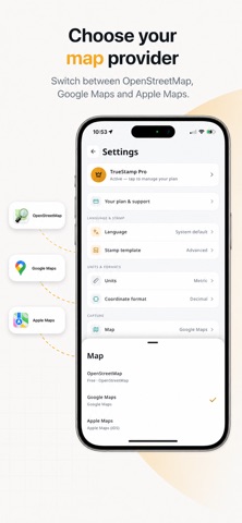
- Optional mini-map thumbnail (OpenStreetMap, or Google and Apple maps on Pro)
- Custom notes, project folders and your own logo
MADE FOR THE WAY YOU WORK
- Fully RESIZABLE overlay - position and size the stamp so it never covers what matters
- Export a designed PDF report, plus CSV, GPX and KML data
- Works offline - uses your last known location in low-signal rural sites
- Save, sort into project folders and share your record with its data intact
MADE FOR EVERYONE
15 languages including Hindi, Gujarati, Tamil, Bengali and Urdu (with full right-to-left support), tuned for real fieldwork across construction, agriculture, logistics and government surveys - plus global English.
Free with ads. Go Pro to unlock Google and Apple map stamps, the scannable Maps QR, PDF