CoordKit: MGRS UTM Map & GPS

CoordKit: MGRS UTM Map & GPS Summary
CoordKit: MGRS UTM Map & GPS is a free, with in-app purchases iOS app in Maps And Navigation by Benthotage Udayashan. Released in Sep 2026 (recently released ago). Store last updated Sep 18, 2026
CoordKit: MGRS UTM Map & GPS SDKs Summary
App not yet scanned for SDKs.
0★
Ratings:
Screenshots


App Description
CoordKit reads your exact position and turns it into something you can use: a grid reference, a converted coordinate, a stamped photo, an exported file.
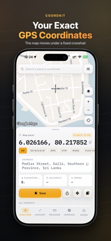
Aim the crosshair at any point on the map and CoordKit shows its GPS coordinates live — in MGRS, UTM, DMS, decimal degrees or Plus Codes. The map moves under a fixed reticle, so your thumb never covers the number you are reading.
EVERY COORDINATE FORMAT, ON ONE PANEL
• MGRS map grids and UTM zones
• DMS (degrees, minutes, seconds) and decimal degrees
• Latitude longitude with hemisphere letters, plus Plus Codes
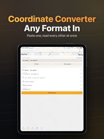
• A coordinate converter that reads any format you paste
Paste a grid reference, a DMS string or a latitude longitude pair and the coordinate converter returns every other format at once. Switch the readout to an MGRS map grid and the crosshair keeps up as you pan — a UTM geo map reference without the handheld unit.
CoordKit works as a grid reference finder for any point you can put a crosshair on. Because the grid reference finder runs off the map rather than a search box, it works for the corner of a field that has no address.
WHAT THE PANEL TELLS YOU ABOUT A POINT
Every point carries more than its GPS coordinates. CoordKit reads the height above sea level, the horizontal accuracy of the fix, and a reverse-geocoded address for the spot the crosshair is on — so a set of latitude longitude numbers becomes somewhere you can describe to someone else.
The accuracy figure is not decoration. CoordKit truncates the coordinate to the precision the fix actually justifies, so you are never shown six decimal places of a three-metre reading.
Save any point to a searchable library with a name, its address and the format you were reading it in. Reopen it months later and the same latitude longitude pair, the same MGRS map reference and the same DMS string are all still one tap apart.
GEOTAG AND STAMP PHOTOS
The stamped camera burns coordinates, address, elevation, accuracy and time into the image and writes them to EXIF as well. Use it to geotag photo evidence for a claim, a job sheet or a site record — the position is in the pixels and in the file. It is a timestamp camera and a coordinate camera at once, so nothing needs re-photographing to add the other half.
It is the gps map camera idea done properly: a typeset panel, not a scrawled watermark. Add location to photo automatically, and