NavLink US
NavLink US Summary
NavLink US is a with in-app purchases iOS app in Maps And Navigation by DigitalYacht Ltd.. Released in Feb 2014 (12 years ago). It has 2.00 ratings with a 3.00★ (mixed) average. Based on AppGoblin estimates, it reaches roughly 9.00 monthly active users and generates around $<10K monthly revenue (100% IAP / 0% ads). Store last updated Oct 31, 2024
NavLink US SDKs Summary
App not yet scanned for SDKs.
3★
Ratings: 2.00
Screenshots


App Description
Marine Navigation App that turns your Apple Device in to a full function chart plotter. Features include:
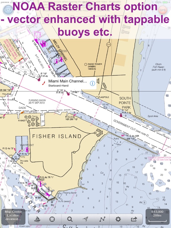
· Realtime GPS position plotted on Marine charts derived from NOAA data (Vector (ENC) & Raster (RNC))
· AIS overlay when connected to compatible wireless AIS system
· Waypoints & routes with full route editing and planning function
· Position, COG, SOG, VMG, bearing, distance & ETA displays
· Configurable chart layers
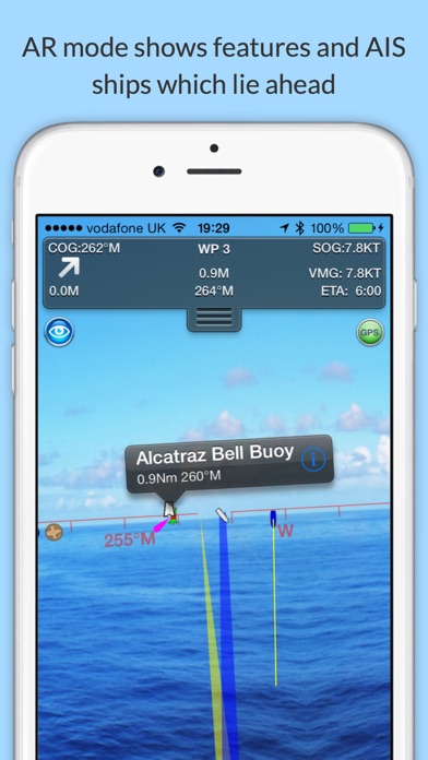
· HorizonView overlays navaid and targets onto iPad/Phone camera display
· Automatic free chart updates included for 1 year
· Weather buoy data
· A-B chart ruler for quick & easy bearing and distance measurement
· All NOAA US charts are included in the price
· Optional in-app purchase of CA charts
AIS Functionality
When connected to an AIS system via a wireless NMEA link, NavLink will provide a real time overlay of AIS targets and CPA and TCPA alarms. Internet AIS requires Boat Beacon app
HorizonView
Overlay chart & AIS objects on the iPhone or iPad camera image to create an augmented HorizonView display, that makes Nav-Aid & vessel identification simple and reliable
Plan & sail routes
Instant route and waypoint creation by tapping on screen. Route reverse function and route overview with inter-leg bearing and distance. Share your routes via dropbox and email with other users
NavLink Charting
NavLink utilises the latest S57 based NOAA digital mapping & features automatic free updates for 1 year. With vector mapping, you can manage your layers of data to de-clutter the screen or maximise information. NavLink supports all key charting feature such as buoys, lights, bridges, depth contours, spot depths, depth contours, anchorage & military areas, weather buoys
Interfacing
NavLink is compatible with all Digital Yacht's wireless NMEA devices such as the iAIS, WLN10, WLN10HS, NavLink, iNavHub & PilotLink that stream wireless AIS data to your Apple device
If you have a WiFi-only iPad you will need an external Bluetooth GPS receiver to enable navigation. 3rd Party units are available such as the Garmin Glo.
Please note: Continued use of GPS running in the background can dramatically decrease battery life
Subscriptions
Your purchase includes 12 months free updates to the included chart set. At the end of the 12 month period continued access to ongoing chart updates is available via an in-app purchase. Charts for ot