Europe Rivers Canals/Waterways
Europe Rivers Canals/Waterways Summary
Europe Rivers Canals/Waterways is a with in-app purchases iOS app in Travel And Local by Bist LLC. Released in Jan 2014 (12 years ago). Store last updated Jun 18, 2022
Europe Rivers Canals/Waterways SDKs Summary
App not yet scanned for SDKs.
0★
Ratings:
Screenshots
App Description
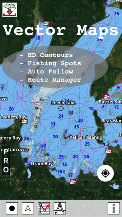
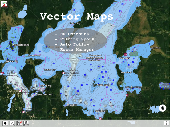
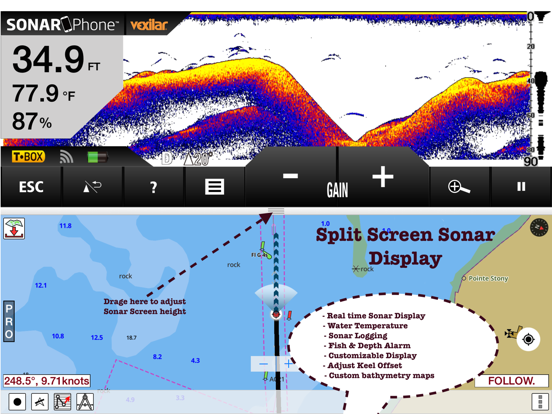
Europe Inland Rivers/Waterways Navigation / Charts App offers access to nautical charts covering major rivers, canals and waterways in Europe - Danube/Donau/Dunaja, Sava, Drava, Rhein, Ruhr, Saar, Sulina, Mosel/Moselle, Elbe, Dijle, Zeekanal etc. All charts include POI data. It supports Marine Charts course up orientation. It has route manager to create new boating routes or import existing GPX/KML routes.
Only marine navigation app to have route assistance with Voice Prompts for marine navigation.
* Voice Prompts for marine navigation / nautical naviagtion (requires GPS )
-prompts when approaching a boating route marker
-Continous distance and ETA updates
-Alerts when sailing/boating off route
-Alerts when boating in wrong direction
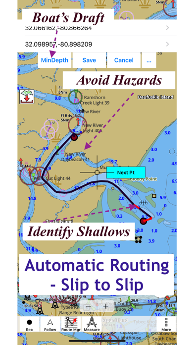
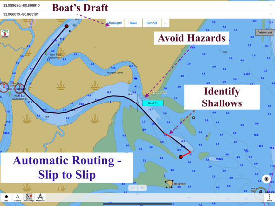
►SLIP TO SLIP AUTO ROUTING
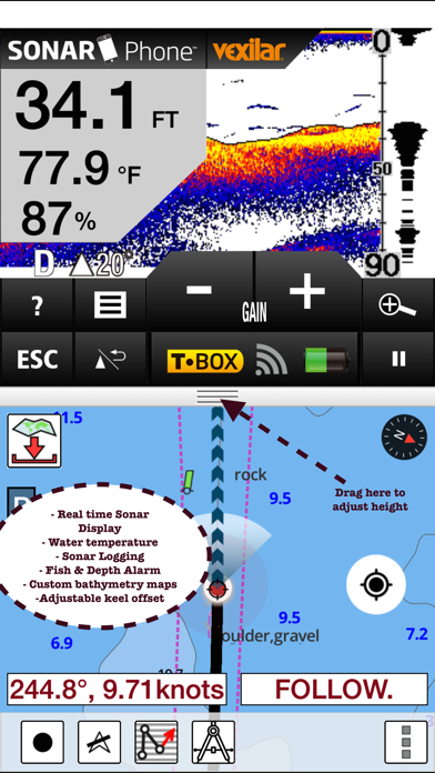
►Instrumentation
√ Marine AIS & (NMEA AIS and GPS over TCP/UDP)
√ Wind direction & Speed,Marine Sonar depth,Water temperature
*** For any question, contact support at gpsnauticalcharts.com / http://www.gpsnauticalcharts.com ***
*Route Editing/Creation
-Create routes from scratch
-Edit existing GPX/KML routes.
-Add custom description to any route point.
-Drop markers along route.
* Offline charts
-Visually draw area to download
-Textual search
-Catalog
-Charts reprojected for WGS84 datum.
*Seamless chart quilting of marine charts
*Distance Bearing tool
*Create custom way points
- Using GPS
-Select point on map
-Manually enter latitude & longitude coordinates
*POI layer for marine charts
- Overlay POIs
- POI list derived from the equivalent ENC and contains all categories including Buoy, Light, Harbour facility, Obstr.
*Search POIs/Way points
*Pan/Zoom/My Location
* Record Marine GPS tracks
* View tracks overlay
* Live track animation
* Track analytics/stats
* Export GPX trcks.
-Export to SDCard
-Share GPX trakcs with friends
* Auto Follow Mode (Course up)
-Continuously updates boat's location on chart
- Adjustable update frequency
Sample Nautical Charts (please visit http://gpsnauticalcharts.com/main/folio-catalog-nautical-charts-app for complete list)
*Austria - Donau
*Belgium - Rupel, Netekanaal, Ringvaart om Gent, Schelde-Rijnverbinding, Dijle, Kanaal naar Charleroi, Beneden Zeeschelde, Bocholt-Herentals, Gent-Terneuzen, van Zeebrugge Achterhaven-inclusief het Boudewijnkanaal-tot en met haven Brugge, Zuid-Willemsvaart, Antwerpen Haven, Moervaart, Beneden-Nete, Dessel-Kwaadmechelen, Estu