Geographica | offline map

Geographica | offline map Summary
Geographica | offline map is a free, ad-supported, with in-app purchases iOS app in Maps And Navigation by keiji matsumoto. Released in Oct 2014 (12 years ago). It has 10 ratings with a 4.90★ (excellent) average. Based on AppGoblin estimates, it reaches roughly 35 monthly active users and generates around $<10K monthly revenue (27% IAP / 73% ads). Store last updated Oct 14, 2026
SDK intelligence: AppGoblin detected 3 development tools(e.g. Google), 2 ad networks,and 1 analytics: product integrated into Geographica | offline map. View full SDK list →
Geographica | offline map SDKs Summary
Geographica | offline map was last scanned for SDKs on 2026-07-04. Below is the overview of third-party companies detected in the app. The full list of SDKs, permissions and unknowns is available here.
 Google
 AdMob
AdMob nanopb
 OpenID
 Firebase
4.9★
Ratings: 10
Screenshots




App Description
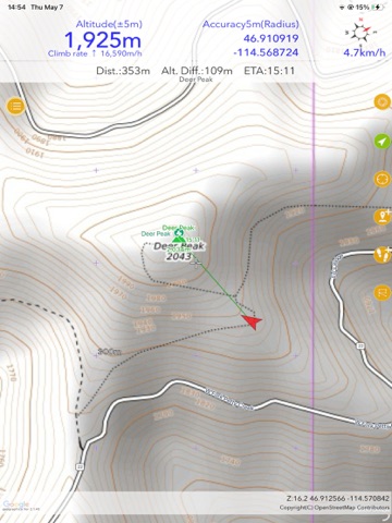
A GPS navigation app for hiking and mountaineering that works offline, even in airplane mode or out of cell range. With Geographica on your iPhone, you can help prevent getting lost or stranded. Your current location is displayed accurately on topographic maps even deep in the mountains, and you can record the route you walked.
■ How to Use
Search "Geographica how to use" on YouTube for tutorial videos.
■ Quick Tips
・Slide the coordinate bar at the top of the screen to reveal the search bar. Search by mountain or place name.
・The third button from the top on the right shows your current location. Long-press to turn it green and lock your location to the center. Tap again to turn it yellow for free scrolling.
・The third button from the bottom registers a marker at the screen center.
・The second button from the bottom starts GPS log recording.
・The menu button in the upper left gives access to all functions.
・If you're unsure how to operate something, long-press the menu button for context-relevant functions.
■ Main Features
・Nearly all features are free to use.
・Cache-based offline GPS app. Maps you view are automatically saved and can be accessed without cell coverage. Older maps are automatically deleted based on capacity and age, so your storage won't fill up.
・Supports various maps including detailed topographic maps from the Geospatial Information Authority of Japan and OpenStreetMap. Usable worldwide for city walks and overseas trekking.
・Distance and elevation units support meters, miles, nautical miles, and feet.
・Coordinate displays include latitude/longitude (DD, DDMM, DDMMSS), UTM, and MGRS.
・Equipped with essential mountaineering features: GPS logging, marker registration and display, and route guidance.
・Voice route guidance and shake-to-speak features let you get information without screen operation—useful in snowy mountains or other situations where screen use is difficult.
・Save maps via Wi-Fi to use the app on devices without a data plan.
・Popular as teaching material for map-reading courses.
■ Compatible Devices
iPhone and iPad running iOS 16 or later. Apple Watch supported.
■ FAQ
Q. My current location isn't displayed.
A. Location can't be determined if GPS is off. Turn on "Location Services" in Settings. Accuracy may suffer indoors, underground, in urban canyons, or in valleys. Try somewhere w