Speedometer, Speed Limit Alert
Speedometer, Speed Limit Alert Summary
Speedometer, Speed Limit Alert is a with in-app purchases iOS app in Maps And Navigation by Dmitriy Kharutskiy. Released in Jul 2014 (11 years ago). It has 16 ratings with a 4.50★ (excellent) average. Based on AppGoblin estimates, it reaches roughly 24 monthly active users and generates around $<10K monthly revenue (100% IAP / 0% ads). Store metadata: updated Feb 14, 2026.
Store info: Last updated on App Store on Feb 14, 2026 .
4.5★
Ratings: 16
Screenshots
App Description
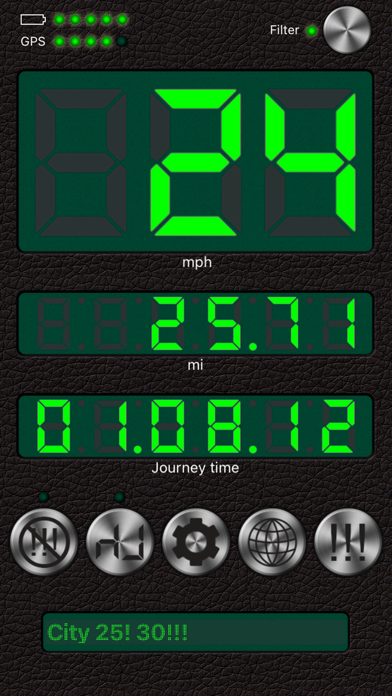
1. Step-by-step audio notifications once you have reached your required speeds.
2. Speed data filtering. Readings with the filter on are more inert than those with the filter off though. THE FILTER MUST BE ON WHEN CYCLING, JOGGING OR WALKING.
3. The G-meter. Get APPROXIMATE acceleration calculated based on your speed variation. Why use the GPS G-meter: no need to keep your iPhone in a fixed position or connect it to your vehicle’s computer system, which means speed readings can be taken discreetly, for example, during a test drive. Taking a number of readings compensates lesser accuracy. Acceleration is calculated only when the filter is off. Acceleration cannot be measured near tall buildings, in the mountains or woods.
4. Large, well-lit digits
5. HUD (the speed is displayed in the windscreen reflection at night time or in cloudy weather)
6. Background mode. Continued use of GPS running in the background can dramatically decrease battery life.
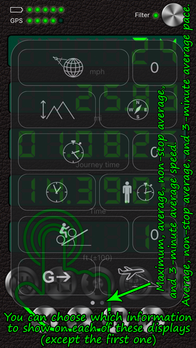
7. Speed and acceleration graphs
8. Odometer
9. Altimeter
10. Time, journey duration, and current stop duration. The current stop duration will be reset after 20 seconds of motion.
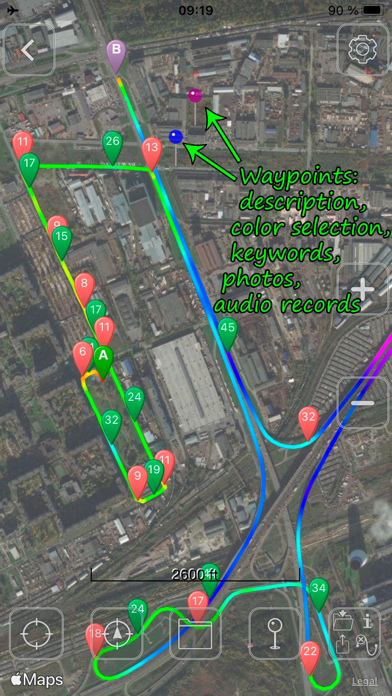
11. See tracks on the map
12. Save tracks
13. Compass
14. Angle of incline (inclinometer)
15. Aircraft descent/climb angle
16. Get detailed stats for any part of your journey
17. Export your journey to a KMZ or GPX file
18. Export track statistics table to a CSV file
19. Load and show your route (journey plan) on the map together with a track. To do this, create a route, using a special online service (such as GPX Editor - https://www.gpxeditor.co.uk/map, The online GPX file editor - https://gpx.studio/, Track drawing websites - https://wiki.openstreetmap.org/wiki/Track_drawing_websites) on your desktop, and export it as a GPX (KML, CSV) file. The file name must begin with "Route". Using iTunes, transfer the file into the app (OR use the "Files" app). Following this, you will be able to select your route at the bottom of your track list. Now you can easily travel following your route line, even without loading a map.
20. Export and import files via iTunes and email
21. Waypoints (description, color selection, keywords, photos, audio records)
22. A single waypoint database with a filter option
23. Music controls
Audio alert settings:
• "60! 70!! 80!!!": One audio signal once you go over 60, a continuous signal fo