Handy GPS lite
Handy GPS lite Summary
Handy GPS lite is a ad-supported Android app in Maps And Navigation by BinaryEarth. Released in Aug 2012 (13 years ago). It has about 4.1M+ installs and 7.6K ratings with a 4.28★ (good) average. Based on AppGoblin estimates, it reaches roughly 1.1M monthly active users and generates around $50K+ monthly revenue (0% IAP / 100% ads). Store metadata: updated Nov 16, 2025, version 443.
Recent activity: 813.3K installs this week (1.7M over 4 weeks) showing exceptional growth , and -1 new ratings this week View trends →
Advertising: AppGoblin detected 1.00 monetized ad creatives shown inside the app.
Data tracking: SDKs and third-party integrations were last analyzed on Sep 26, 2025. The app's network data flows (API traffic to/from the app and its SDKs) were last crawled on Jan 25, 2026.
Store info: Last updated on Google Play on Nov 16, 2025 (version 443).
Handy GPS lite was last scanned for SDKs 2025-09-26. Below is the overview of third party companies detected in the app. The full list of raw SDKs, app permissions and unknown SDKs is available here.
4.28★
Ratings: 7.6K
Screenshots

App Description
A hiking GPS for the real world (lite version). No signup required.
The perfect companion for your next outdoor adventure. Seek, find, record and return home with Handy GPS. No user account or setup required - just install it, turn on your GPS and go!
This app is a powerful navigation tool designed for outdoors sports like hiking, bushwalking, tramping, mountain biking, kayaking, horse trail riding, and geocaching. Its also useful for surveying, mining, archaeology, and forestry applications. Its simple to use and works even in the remotest back country since it doesn't require network connectivity. It allows you to work in UTM or lat/lon coordinates so you can even use it with your paper topographic maps.
NOTE: This is a free trial version and is limited to storing only 3 waypoints, and 40 track log points. You can use the trial version for as long as you want, but if you like this app, please install the paid version of "Handy GPS" to get an unlimited version with lots more features. Thanks!
Also, allow the app to always use GPS, and turn off battery optimisation for the app to reliably record tracklogs when the phone screen is off.
BASE FEATURES:
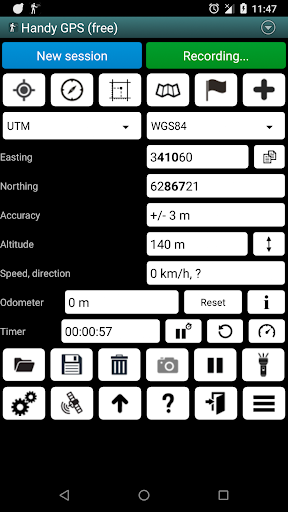
* Shows your current coordinates, altitude, speed, direction of travel, and total distance travelled in metric, imperial/US, or nautical units.
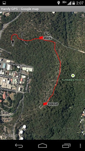
* Can store your current location as a waypoint, and record a track log to show where you've been on a map.
* Data can be imported from and exported to KML and GPX files.
* Allows manual entry of waypoints in UTM, MGRS and lat/lon coords.
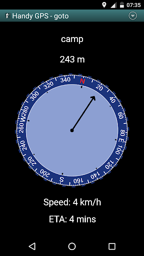
* Can guide you to a waypoint using the "Goto" screen, and optionally sound an alert when when you're getting close.
* Has a compass page which works on devices with magnetic field sensors.
* Automatically computes the local geoid offset to improve altitude accuracy
* Supports the world-wide WGS84 datum along with the common Australian datums and map grids. You can use WGS84 for NAD83 maps in the US.
* Shows GPS satellite locations and signal strengths graphically.
* Can display simple or MGRS grid references.
* Can compute waypoint-to-waypoint distance and direction.
* Includes an optional timer line to record walk duration and compute your average speed.
* Thoroughly tested by the developer on many off-track walks
EXTRA FEATURES ONLY IN THE PAID VERSION:
* No ads.
* An unlimited number of waypoints and track log points.
* Offline maps.
* Custom datums.
* Elevation p