RunwayMap: Aviation Weather
RunwayMap: Aviation Weather Summary
RunwayMap: Aviation Weather is a with in-app purchases Android app in Weather by RedDev GmbH. Released in Jun 2017 (8 years ago). It has about 30.2K+ installs and 179 ratings with a 3.62★ (average) average. Based on AppGoblin estimates, it reaches roughly 506 monthly active users and generates around $<10K monthly revenue (100% IAP / 0% ads). Store metadata: updated Apr 7, 2025, version 372.
Recent activity: 54 installs this week (202 over 4 weeks) showing steady growth View trends →
Data tracking: SDKs and third-party integrations were last analyzed on May 20, 2026. The app's network data flows (API traffic to/from the app and its SDKs) were last crawled on Jun 23, 2025.
Store info: Last updated on Google Play on Apr 7, 2025 (version 372).
SDKs, Trackers & Permissions
RunwayMap: Aviation Weather was last scanned for SDKs 2026-05-20. Below is the overview of third party companies detected in the app. The full list of raw SDKs, app permissions and unknown SDKs is available here.
App Details
App Store
Ads & App-Ads.txt
AppGoblin SDK Scans
3.62★
Ratings: 179
Screenshots


App Description
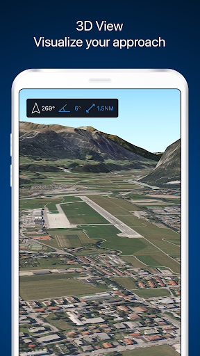
Visualize landings in 3D & check the aviation weather.
RunwayMap is the #1 pilot community all about the passion of flying. You can view flight videos, reviews and photos from other pilots as well as share your flying experiences.
The interactive map gives you an overview of the airports. We have collected important information on every airport:
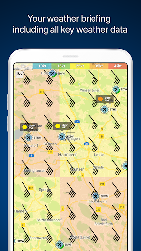
• Aviation weather forecasts
• Runways & NOTAM
• 3D and satellite views
• Webcams and much more
RunwayMap simplifies flight preparation and complements flight planning tools such as ForeFlight, Jeppesen and Garmin Pilot.
Download the versatile pilot app while you are at it.
Features:
MAP
Search by name or ICAO to discover new airports. Receive important information such as the current weather, address, position, runways, and sunrise/sunset. Mark and save what airports you’ve already flown to or those you’d like to fly to next. Save your personal notes for every airport.
AVIATION WEATHER
Current weather reports, visual flight conditions und wind forecasts are shown on our map.
ON-SITE SERVICES
Discover restaurants and hotels near the airport. Get informed about public transport and car rental offers.
3D AND SATELLITE VIEWS
Check out the airport environment in 3D and satellite views. Use the OpenStreetMap view for detailed vehicle access information.
DOCUMENTS
With just a few clicks, add your flight documents, such as the Jeppesen approach charts, FAA terminal procedures and airport diagrams, Foreflight manuals or the Garmin pilot’s guide. That way you always have them close at hand.
TOOLS
Use the handy calculator for conversions for distance, weight, temperature, and more. Have it display your QNH and QFE.
RUNWAYMAP APP
Important note: RunwayMap is not intended to provide aeronautical information or navigation aids. For navigation purposes, we strongly recommend using only approved and updated aviation information such as ForeFlight, Jeppesen or Garmin Pilot.
The weather data shown in RunwayMap is only general information about possible weather development. It does not replace professional weather briefing by an official body before the flight.
Learn more about RunwayMap at runwaymap.com