Compass Waypoints: GPS measure
Compass Waypoints: GPS measure Summary
Compass Waypoints: GPS measure is a ad-supported Android app in Tools by AHByte. Released in Jun 2022 (4 years ago). It has about 662+ installs Based on AppGoblin estimates, it reaches roughly 86 monthly active users and generates around $<10K monthly revenue (0% IAP / 100% ads). Store last updated Jul 6, 2026
Recent activity: 4.00 installs this week (16 over 4 weeks) showing steady growth View trends →
Compass Waypoints: GPS measure SDKs Summary
App not yet scanned for SDKs.
0★
Ratings: 0
Screenshots


App Description
Measure area/distance, navigate to waypoints, and track satellite coverage.
Transform your phone into a professional GPS tool. Measure area and distance, navigate with waypoints, track live GPS satellites, and use the smart compass – all in one app.
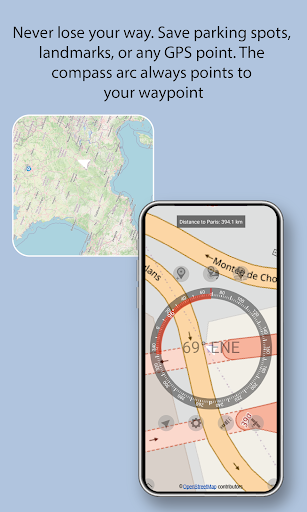
SMART WAYPOINTS (NEW!)
Save up to 10 waypoints anywhere on Earth. Activate any saved waypoint and your compass shows a live ARC pointing from your current position to the waypoint. Perfect for navigating to saved locations without constantly watching the map.
• Save up to 10 waypoints with name and coordinates
• Visual arc on compass points exactly to your waypoint
• Works at ANY distance – local or global
• Note: at extreme distances (thousands of km), map position may show slight curvature effects, but the compass arc remains PRECISE
• Perfect for: hiking, geocaching, finding your parked car, returning to landmarks
MEASURE AREA & DISTANCE BY GPS
Tap on the map to add points. Measure any surface or path with high accuracy.
• Area: m², km², ft², acres
• Distance: meters, km, feet, miles
• Drag and drop markers to adjust
• Real-time results as you add points
Perfect for: land surveying, construction, gardening, real estate, hiking trails.
BUILT-IN COMPASS WITH WAYPOINT GUIDANCE
Real-time magnetic compass integrated directly into the map.
• Magnetic heading or True North (user selectable)
• Magnetic field monitoring (µT)
• Calibration alerts when interference detected
• Pitch and roll sensors
• Plus: waypoint arc guidance when waypoint is active
LIVE SATELLITE SKY MAP
See exactly which GPS satellites are above you.
• Real-time position: azimuth & elevation (0° horizon to 90° zenith)
• Signal quality (SNR) with color coding
• See which satellites are IN USE vs just VISIBLE
• Supports GPS, GLONASS, Galileo, BeiDou
GPS LOCATION TOOLS
• Real-time coordinates (multiple formats)
• Live address display
• One-tap map centering
KEY FEATURES
• One button switches between Compass, Area, and Distance modes
• Adjustable compass opacity on map (20% - 100%)
• Multi-touch map: zoom, pan, navigate
• Drag markers to edit measurements anytime
FLASHLIGHT WITH SOS MODE
• Steady LED light
• Emergency SOS blinking signal
WHY THIS APP?
- No extra hardware – uses your phone's GPS and sensors
- One app replaces: GPS meter + compass + satellite finder + area calculator + waypoint navigator
Download now. One tool. Everything you need.