50 US State Flags & Maps
50 US State Flags & Maps Summary
50 US State Flags & Maps is a ad-supported Android app in Education by APK Store. Released in Aug 2022 (3 years ago). It has about 1.6K+ installs and 19 ratings with a 4.50★ (excellent) average. Based on AppGoblin estimates, it reaches roughly 48 monthly active users and generates around $<10K monthly revenue (0% IAP / 100% ads). Store metadata: updated Feb 5, 2026.
Recent activity: 14 installs this week (49 over 4 weeks) showing below average growth View trends →
Store info: Last updated on Google Play on Feb 5, 2026 .
4.5★
Ratings: 19
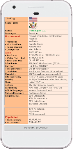
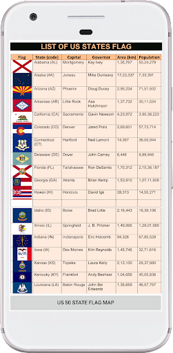
Screenshots


App Description
Learn all 50 US state flags, maps, capitals and basic geography
50 US State Flags & Maps is an educational app created to help users learn about the
United States through state flags, maps, capitals and regional geography.
This app allows you to explore all 50 US states with clear state flags, easy-to-read
maps and capital city information. It is designed for students, learners and anyone
interested in understanding US geography in a simple way.
App Highlights
✔ All 50 US state flags in one place
✔ US state maps with state names and capital cities
✔ Regional maps of the United States including West, Midwest, South and Northeast
✔ North America map showing the USA and surrounding countries
✔ Offline access after initial load
✔ Clean and distraction-free design
What You Can Learn
• Identify each US state by its flag
• Locate states on the US map
• Learn capital cities of all 50 states
• Understand regional divisions of the United States
This app is useful for school students, teachers, quiz preparation, travelers and
general learners who want a quick reference to US state flags and geography.
This app is developed for educational and reference purposes only and is not
affiliated with any government organization.