Land Calculator: Map Measure
Land Calculator: Map Measure Summary
Land Calculator: Map Measure is a ad-supported, with in-app purchases Android app in Tools by Disciple Skies Software. Released in Jun 2013 (12 years ago). It has about 414.7K+ installs and 2.3K ratings with a 4.18★ (good) average. Based on AppGoblin estimates, it reaches roughly 2K monthly active users and generates around $<10K monthly revenue (52% IAP / 48% ads). Store metadata: updated May 19, 2026.
Recent activity: 188 installs this week (691 over 4 weeks) showing steady growth , and 18 new ratings this week View trends →
Store info: Last updated on Google Play on May 19, 2026 .
4.18★
Ratings: 2.3K
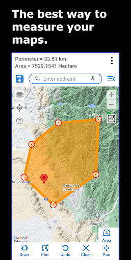
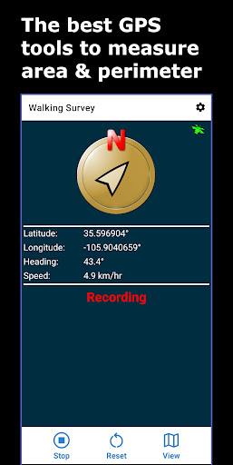
Screenshots


App Description
The most accurate and easiest way to make land surveys and map measurements.
Land Calculator is a powerful, yet easy-to-use app for making area and perimeter measurements for any location.
Measure the perimeter and area of any area on a map or use your device's GPS to get the area, perimeter and path length for a place that your walk or drive.
The app's most commonly performed tasks include:
📏 Create a field survey by drawing any shape on a map to get its enclosed area and perimeter. Combine points and curves to make the best possible map survey. Supports any shape you can draw!
📏 Get land area and perimeter for any shape field by walking or driving its perimeter.
📏 Measure point to point distances with various map tools and survey tools.
📏 Area and perimeter unit conversion tool.
📏 Shortest distance to a line with accurate connecting geodesics.
The app includes:
● Selection of coordinate systems including: WGS 84, British Ordnance Survey (OSG36 Datum), ANS, NAD 27, ED 50, NAD 83 and several others.
● A backup and restore feature: Secure and restore your work using the app's kml backup and importing features. Share surveys to colleagues who may view your work in Google Earth on their desktop computer or phone or in Land Calculator. Got a new phone and all your work is on the old phone? No problem! Import all your old work into your new phone with the application's single click restore process.
● Use the data generated by this application in ArcGIS by converting the app's KML files with ArcGIS' KML2Layer feature, or, use KML Tools to convert the application's KML files to DXF (Drawing Exchange Format) for use in drawing programs like AutoCad and SketchUp.
A GPS-controlled compass and GPS reporting are included to assist with your field surveys.
Who uses this app?
● Used by farmers to calculate equipment needs, seed requirements, estimate water usage, estimate harvest quantity and crop value.
● Used by Real Estate agents to measure property size.
● Insurance agents use the app to measure property size for adjustment purposes.
● Property inspectors use the app to get property measurements used in mortgage calculations.
● Used by land improvement businesses to estimate fencing supply needs and other construction supplies.
If you need to make a highly specialized type of calculation and you don't see the tools in the