DroneSense
DroneSense Summary
DroneSense is a mobile Android app in Maps And Navigation by DroneSense. Released in Apr 2022 (4 years ago). It has about 6.5K+ installs and 9.00 ratings with a 4.43★ (good) average. Based on AppGoblin estimates, it reaches roughly 537 monthly active users . Store metadata: updated Mar 25, 2026.
Recent activity: 149 installs this week (545 over 4 weeks) showing exceptional growth View trends →
Store info: Last updated on Google Play on Mar 25, 2026 .
4.43★
Ratings: 9.00
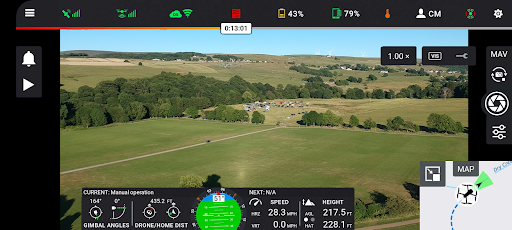
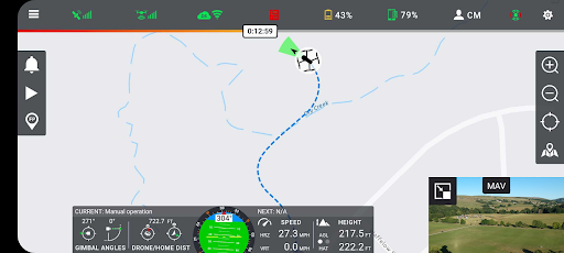
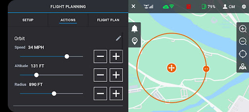
Screenshots
App Description
Public Safety Drone Platform
For UAS Pilots:
Fly a wide range of professional drones with DroneSense! Simply download this app directly onto your Android device and plug directly into any drone remote. Incorporating the latest and greatest drone is easy; there is no new training as the pilot will always fly with our app and have the same experience, no matter what drone is chosen. Share your live video stream with incident commanders easily to enable increased situational awareness on-scene. Automated flight logging ensures all data from all flights are available at any time.
For Program Administrators:
DroneSense is your complete system of record. It is a complete asset and risk management tool that provides accountability and transparency across your organization. Organize your people, hardware, and flight history in a powerful but intuitive interface. Whether it is automatically logging flight hours, filing NOTAMs, or managing personnel, DroneSense is your one-stop solution. Our software lets you quickly leverage all your resources so you can spend more time focused on the mission at hand.
For Incident Commanders:
DroneSense gives incident commanders and remote stakeholders the power to strategize and tactically collaborate. Our Operations Hub enables you to share real-time, low-latency, high definition views of a scene and plan dynamically. Anyone with a connected device can see a live pilot session, and multiple drone pilots can work together seamlessly.
Please note that usage of the DroneSense Platform requires user registration and authorization from accredited public safety agencies.