Mercator Projection Converter

Mercator Projection Converter Summary
Mercator Projection Converter is a ad-supported Android app in Tools by Hau Vu. Released in Dec 2021 (4 years ago). It has about 3.4K+ installs Based on AppGoblin estimates, it reaches roughly 150 monthly active users and generates around $<10K monthly revenue (0% IAP / 100% ads). Store metadata: updated Nov 3, 2023.
Store info: Last updated on Google Play on Nov 3, 2023 .
0★
Ratings: 0
Screenshots

App Description
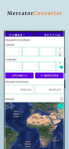
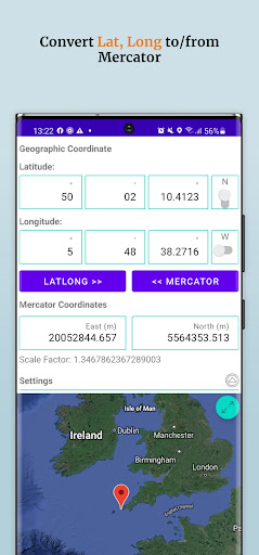
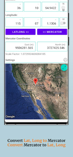
Convert GEO (Latitude, Longitude) to Mercator (East, North) coordinates
The Mercator map projection is a special limiting case of the Lambert Conic Conformal map projection with the equator as the single standard parallel. All other parallels of latitude are straight lines and the meridians are also straight lines at right angles to the equator, equally spaced. It is the basis for the transverse and oblique forms of the projection. It is little used for land mapping purposes but is in almost universal use for navigation charts. As well as being conformal, it has the particular property that straight lines drawn on it are lines of constant bearing. Thus navigators may derive their course from the angle the straight course line makes with the meridians.
This app helps you convert latitude, longitude to X,Y coordinates on Mercator map projection base on users parameters such as Ellipsoid, latitude of origin, longitude of origin, false easting, false northing...
MAIN FEATURES:
• Convert geographic coordinates (latitude, longitude) to Mercator coordinates (X, Y)
• Convert Mercator coordinates to geographic coordinates.
• Calculate scale factor of conversion point
• Display a marker on map to show converted point.
• Supports 3 different latitude / longitude input formats:
* Decimal degrees (DD.DDD)
* Degrees /decimal minutes (DD MM.MMM)
* Degrees / minutes and decimal seconds (DD MM SS.SSS).
• Display your location on map in geographic and Mercator coordinates.
• Supports many map types such as hybrid, terrain, satellite or street maps.