バス停マップ(時刻表、接近情報、運行状況)
バス停マップ(時刻表、接近情報、運行状況) Summary
バス停マップ(時刻表、接近情報、運行状況) is a ad-supported Android app in Maps And Navigation by Hideshi Otsuru. Released in Dec 2013 (12 years ago). It has about 39.8K+ installs Based on AppGoblin estimates, it reaches roughly 1.7K monthly active users and generates around $<10K monthly revenue (0% IAP / 100% ads). Store metadata: updated Apr 3, 2026.
Recent activity: 15 installs this week (69 over 4 weeks) showing steady growth View trends →
Store info: Last updated on Google Play on Apr 3, 2026 .
0★
Ratings: 0
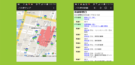
Screenshots


App Description
Display timetable the bus stop on the map, approach information, you can also check the operation status.
I quickly find a nearby bus stop.
Specify the bus stop name to Find its position.
I see the timetable of bus stop.
Bus service situation, I confirm the approach information. (Part of the bus operators)
Please use for purposes such as.
● operation status, bus operators that can display approach information
Toei bus, international box office bus, Osaka city bus, Nishitetsu, Kyoto city bus, Seibu, Kanagawa Chuo Kotsu Co., Ltd., Tokyu, Nagoya city bus, Sendai city bus, Keisei Bus, Keihan bus, Keihin Express bus, ShizuTetsu just line, Yokohama city bus, new Keisei bus, Odakyu, Kawasaki city bus, Hakodate bus
● Main features
- I will display the current location near the bus stop on the map.
- Find the bus stop name I will displayed on a map.
- Address in the detailed view of the bus stop, bus operators, routes, timetables, operation status, it displays the approach information.
Timetable, operation status, for the approach information is a link to the bus operators of home page.
- I can view the route from the current position to the bus stop. (Car, train, walk)
● Search data
- I am using the data of the country numerical information. (About 240 000)