GPS Map Camera: Photo Location
GPS Map Camera: Photo Location Summary
GPS Map Camera: Photo Location is a ad-supported Android app in Photo And Video by Infinity App Studios. Released in Dec 2024 (1 year ago). It has about 1.5K+ installs Based on AppGoblin estimates, it reaches roughly 27 monthly active users and generates around $<10K monthly revenue (0% IAP / 100% ads). Store metadata: updated Feb 3, 2025.
Recent activity: 9.00 installs this week (44 over 4 weeks) showing above average growth View trends →
Store info: Last updated on Google Play on Feb 3, 2025 .
0★
Ratings: 0
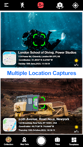
Screenshots


App Description
GPS Map Camera use for geotag photos and to add GPS Location & date time stamps
Capture, tag, and navigate like never before with GPS Map Camera, the ultimate app for photo geotagging, live location sharing, and seamless navigation! Packed with top features, this app is perfect for travelers, professionals, and outdoor enthusiasts.
How to add GPS Map Camera: Photo Location on live photos?
✔ Install GPS Map Camera: Photo Location: geotag photos & add GPS location application in your smartphone.
✔ Open camera & select advanced or classic templates, arrange formats of stamps, change settings according to your requirement of GPS photomaps location stamp.
✔ Add geo location stamps automatically to your clicked pictures
🌟 Top Important Key Features:
GPS Map Camera: Add GPS location, address, date, and time to your photos effortlessly. Perfect for work, travel, and outdoor adventures.
Live Location Sharing: Share your real-time location for safety and easy tracking with friends or family.
Digital Compass: Find directions with accuracy using our built-in compass for outdoor navigation.
Custom Templates: Use unique templates to personalize your geotagged photos for professional or personal use.
Offline Geotagging: Geotag your photos without the need for an internet connection.
Advanced Template Description:
Enhance your geotagged photos with detailed information using the Advanced Template in GPS Map Camera. This feature allows you to capture and display comprehensive location data directly on your photos, including:
🌟 Map Options: Visualize your location with map integration for an easy view of the surroundings.
🌟 Short Address: Display a concise, readable version of the address.
🌟 Full Address: Add the complete address for precise location details.
🌟 Latitude/Longitude: Automatically embed GPS coordinates for exact positioning.
🌟 Plus Code: Include Google's Plus Codes for accurate location sharing, even in remote areas.
🌟 Wind: Capture the wind speed and direction, ideal for outdoor enthusiasts and weather tracking.
🌟 Humidity: Record the humidity level at the moment of capture.
Pressure: Get atmospheric pressure data for a more complete environmental snapshot.
🌟 Altitude: Include altitude to understand your elevation at the time of the photo.
🌟 Accuracy: Display the accuracy of your location based on GPS data for more reliable tagging.
🎯 Why Choose GPS Map Camera: Photo Location?
Trusted by travelers, field workers, and photographers.
Optimized for GPS Navigation, Location Tracking, and Photo Documentation.
Helps you stay organized with geotagged photos and live location tools.
Whether you’re a wanderer, a photographer, or a professional documenting your work, GPS Map Camera: Photo Location is your go-to app. Download now to explore the world with precision and creativity!