Live Earth Map: GPS Satellite
Live Earth Map: GPS Satellite Summary
Live Earth Map: GPS Satellite is a ad-supported, with in-app purchases Android app in Maps And Navigation by Live Earth Globe & Tools Studio. Released in Feb 2024 (2 years ago). It has about 206.7K+ installs and 178 ratings with a 2.47★ (poor) average. Based on AppGoblin estimates, it reaches roughly 18K monthly active users and generates around $<10K monthly revenue (47% IAP / 53% ads). Store metadata: updated Feb 26, 2026, version 55.
Recent activity: 4.8K installs this week (9.5K over 4 weeks) showing declining growth , and 2.00 new ratings this week View trends →
Data tracking: SDKs and third-party integrations were last analyzed on Mar 26, 2026. The app's network data flows (API traffic to/from the app and its SDKs) were last crawled on Oct 28, 2025.
Store info: Last updated on Google Play on Feb 26, 2026 (version 55).
Live Earth Map: GPS Satellite was last scanned for SDKs 2026-03-26. Below is the overview of third party companies detected in the app. The full list of raw SDKs, app permissions and unknown SDKs is available here.
2.47★
Ratings: 178
Screenshots


App Description
Live earth map by gps satellite , instant live satellite view
Live Earth map: GPS Satellite is a versatile and user-friendly application that combines cutting-edge technology with satellite navigation systems. It serves as a comprehensive solution for various needs, ranging from basic location tracking to advanced features like Satellite Finder and Real-Time Timelines. Let's explore the key components that make Earth Map Satellite a go-to choice for GPS navigation enthusiasts.
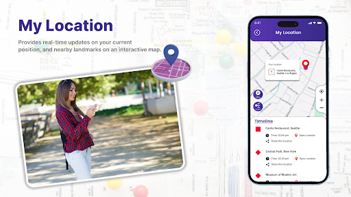
Location Timeline:
One of the fundamental aspects of the Live Earth map: GPS Satellite is its ability to display accurate location-based timeline. Users can easily check the timeline at any location on the globe, allowing for efficient scheduling and coordination across different time zones.
Live Earth Map:
The heart of the module is the Live Earth Map: GPS satellite itself, providing users with a dynamic, real-time representation of the Earth's surface. The map is enriched with up-to-date satellite imagery, offering a vivid and detailed view of landscapes, cities, and geographical features.
Satellite Finder:
A standout feature of the Live Earth map: GPS satellite is the Satellite Finder tool. Users can track the positions of satellites orbiting the Earth in real-time. This functionality is particularly useful for enthusiasts, researchers, and professionals who require precise information about satellite locations for various purposes.
Street View:
Earth Map Satellite goes beyond traditional maps by incorporating a Street View option. Users can virtually explore streets, neighborhoods, and landmarks, gaining a realistic perspective of the environment. This feature is invaluable for both navigation and immersive exploration.
Nearby Places:
The module enhances user convenience by offering a 'Nearby Places' feature. Users can easily locate and explore points of interest, such as restaurants, landmarks, and entertainment venues, providing a seamless integration of navigation and local discovery.
World Clock:
Stay connected with global time zones using the World Clock feature. Whether planning international meetings or keeping track of events across different regions, users can rely on the Live Earth Map: GPS Satellite for accurate and synchronized time information.
Space Wallpaper:
Elevating the user experience, the Space Wallpaper feature allows users to set captivating satellite images or astronomical views as their device wallpaper. This aesthetic touch adds a personalized and visually appealing dimension to the module.
Weather:
Stay informed about current weather conditions with the Live Earth map's integrated weather feature. Users can access real-time updates on temperature, precipitation, and other meteorological data, ensuring a comprehensive understanding of the environment.