Singapore MRT Map Route 新加坡地铁
Singapore MRT Map Route 新加坡地铁 Summary
Singapore MRT Map Route 新加坡地铁 is a mobile Android app in Maps And Navigation by momoStorm Entertainment. Released in Jun 2017 (8 years ago). It has about 282.1K+ installs and 5.3K ratings with a 4.18★ (good) average. Based on AppGoblin estimates, it reaches roughly 15.9K monthly active users . Store metadata: updated Nov 17, 2025, version 34.
Recent activity: 8.6K installs this week (16.6K over 4 weeks) showing exceptional growth , and 20 new ratings this week View trends →
Data tracking: SDKs and third-party integrations were last analyzed on Aug 1, 2025. The app's network data flows (API traffic to/from the app and its SDKs) were last crawled on Jul 22, 2025.
Store info: Last updated on Google Play on Nov 17, 2025 (version 34).
Singapore MRT Map Route 新加坡地铁 was last scanned for SDKs 2025-08-01. Below is the overview of third party companies detected in the app. The full list of raw SDKs, app permissions and unknown SDKs is available here.
4.18★
Ratings: 5.3K
Screenshots


App Description
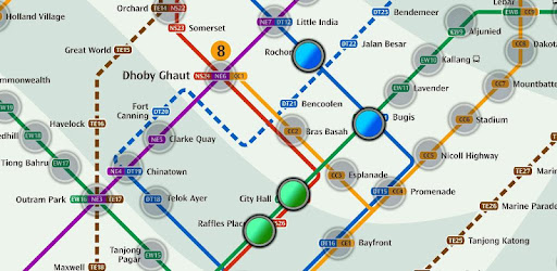
Get the fastest route and time of MRT in a second.
Added Thomson-East Coast Line (TE1 Woodlands North to Orchard) to the subway system.
Singapore's MRT system is extending. By 2030, the MRT system will be more complex than you could image. It's good for all residents on our lovely island. But also will be a problem because we don't know how to travel the fastest when transfering stations.
Singapore MRT Map Route is designed to allows user to get the best route within a second. It will help you save a lot of time over years.
- View lastest Singapore MRT map
- Display the best route between two stations
- Automatically calculate estimated travel time
- Require no internet connection.
Updated to latest MRT system:
Downtown Line(Blue)
Bukit Panjang, Cashew, Hillview, Beauty World, King Albert Park, Sixth Avenue, Tan Kah Kee, Botanic Gardens, Stevens, Newton, Little India, Rochor, Bugis, Promenade, Bayfront, Downtown, Telok Ayer, Chinatown
Circle Line(Yellow)
Dhoby Ghaut, Bras Basah, Esplanade, Promenade, Nicoll Highway[C], Stadium, Mountbatten, Dakota, Paya Lebar, MacPherson, Tai Seng, Bartley, Serangoon, Lorong Chuan, Bishan, Marymount, Caldecott, Botanic Gardens, Farrer Road, Holland Village. Buona Vista, one-north, Kent Ridge, Haw Par Villa, Pasir Panjang, Labrador Park, Telok Blangah, HarbourFront
East West Line (Green)
Pasir Ris ,Tampines , Simei , Tanah Merah , Bedok , Kembangan , Eunos , Paya Lebar , Aljunied , Kallang , Lavender , Bugis , City Hall , Raffles Place , Tanjong Pagar , Outram Park , Tiong Bahru , Redhill , Queenstown , Commonwealth , Buona Vista , Dover ,Clementi , Jurong East , Chinese Garden , Lakeside , Boon Lay , Pioneer , Joo Koon, Expo,
Changi Airport
North South Line (Red)
Jurong East, Bukit Batok, Bukit Gombak, Choa Chu Kang, Yew Tee, Kranji, Marsiling, Woodlands, Admiralty, Sembawang, Canberra, Yishun, Khatib, Yio Chu Kang, Ang Mo Kio, Bishan, Braddell, Toa Payoh, Novena, Newton, Orchard, Somerset, Dhoby Ghaut, City Hall, Raffles Place, Marina Bay, Marina South Pier
North East Line (Purple)
HarbourFront, Outram Park, Chinatown, Clarke Quay, Dhoby Ghaut, Little India, Farrer Park, Boon Keng, Potong Pasir, Woodleigh, Serangoon, Kovan, Hougang, Buangkok, Sengkang, Punggol