Satellite Weather Radar India
Satellite Weather Radar India Summary
Satellite Weather Radar India is a ad-supported Android app in Weather by Bright Rainbow. Released in Mar 2018 (8 years ago). It has about 66.3K+ installs Based on AppGoblin estimates, it reaches roughly 621 monthly active users and generates around $<10K monthly revenue (0% IAP / 100% ads). Store metadata: updated May 11, 2025.
Recent activity: 31 installs this week (96 over 4 weeks) showing steady growth View trends →
Store info: Last updated on Google Play on May 11, 2025 .
0★
Ratings: 0
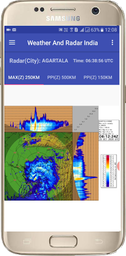
Screenshots


App Description
India weather radar and satellite images
Key Features of Weather & Radar India app:
• This is best Live Weather Report App of India.
• India live Doppler weather radar Images.
• Indian Sector Latest weather Satellite Images.
• Every 10 minutes radar image updated.
• 24 India city's Doppler Weather Radar Images.
• Change your desire city and see the clouds position.
• You will get accurate Weather Forecast.
• Best satellite weather map live india.
• Live insat satellite image india.
• Best weather India App.
• Insat 3D, Insat 3DR and Meteosat-8 Satellite Images.
Doppler Weather Radar Image Features:
• MAX(Z) => Maximum Display(Z) -This radar image gives the clouds position with cloud height within 250 KM range.
• PPZ500 => Plan Position Indicator(Z) -This radar image gives the clouds position within 500 KM range.
• PPZ150 => Plan Position Indicator(Z) -This radar image gives the clouds position within 150 KM range.
• PPV => Plan Position Indicator(Radial Velocity) -This radar image gives the clouds radial velocity within 250 KM range. The radial velocity towards radar site is taken as negative value (-ve) and away from radar site is taken as positive value (+ve).
• VVP2=> Volume Velocity Processing 2-This radar image gives the direction and radial speed of winds in different standard layer/height from surface.
• SRI – Surface Rainfall Intensity -This Image is an image of the rainfall intensity in a user selected surface layer within 100 KM range.
• PAC - Precipitation Accumulation -This Image shows the total rainfall amount in (mm) within 24 Hours. 250 KM range.
DISCLAIMER :
This is a personally developed weather information android application(App). This is not a Government official App or not a Government affiliated App. This is not a India Met Dept official App or not a India Met Dept affiliated App.
SOURCE OF INFORMATION:
https://mausam.imd.gov.in
https://tropic.ssec.wisc.edu
https://www.data.jma.go.jp