Water Map Live - Routes, AIS
Water Map Live - Routes, AIS Summary
Water Map Live - Routes, AIS is a with in-app purchases Android app in Maps And Navigation by Surfcheck. Released in May 2018 (7 years ago). It has about 183.4K+ installs Based on AppGoblin estimates, it reaches roughly 11.7K monthly active users and generates around $<10K monthly revenue (100% IAP / 0% ads). Store metadata: updated Jan 6, 2026, version 127.
Recent activity: 7.4K installs this week (13.1K over 4 weeks) showing exceptional growth View trends →
Data tracking: SDKs and third-party integrations were last analyzed on Mar 26, 2026. The app's network data flows (API traffic to/from the app and its SDKs) were last crawled on Oct 28, 2025.
Store info: Last updated on Google Play on Jan 6, 2026 (version 127).
Water Map Live - Routes, AIS was last scanned for SDKs 2026-03-26. Below is the overview of third party companies detected in the app. The full list of raw SDKs, app permissions and unknown SDKs is available here.
0★
Ratings: 0
Screenshots

App Description
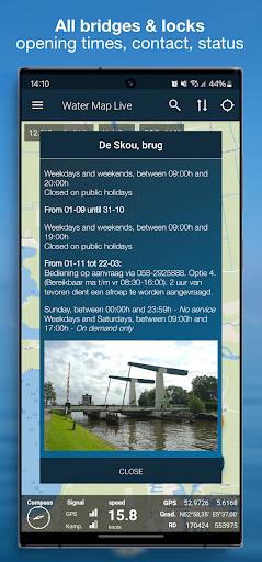
All bridges & locks, live shipping route info, water level, meteo, route planner
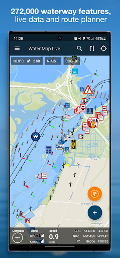
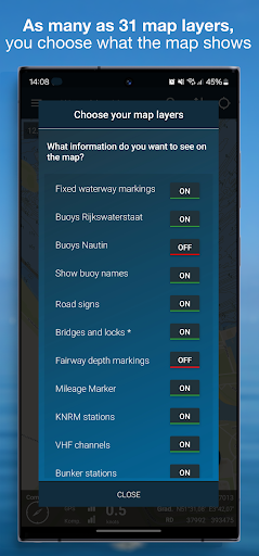
This is by far the most complete waterway and boating chart of the Netherlands, Belgium and Germany. With all fairway features, buoyage, traffic signs and *live* bridges and locks: opening times, telephone numbers and VHF radio channels. More than 272.000 objects on the map, conveniently arranged in map layers that you can switch on and off as desired.
All water charts can be downloaded and used offline.
The app really is LIVE and contains hundreds of current water levels, tidal curves, the weather at sea and in your area, water depths, data from KNRM stations and the water quality of countless Dutch bathing places. And the current notices to skippers (NtS): are there any obstructions on your route? You know it now. Always up to date.
In total, the app contains the data of more than one hundred thousand nautical objects that are shown on the map around you. Thanks to GPS you can also read your speed and current coordinates. With the GPS tracker you can record and save your routes.
The app is based on map material from the Dutch Land Registry and also contains the beautiful 1: 25,000 topographical maps of the Netherlands.
Water Map Live is excellent for offline use, but the live information about bridges & locks, NtS, the current water levels and the current weather naturally uses an internet connection.
Also for Android Auto
The Android Auto app is an extension of Waterkaart Live that you can use if you have a suitable device. To keep the Android Auto app clear and above all fast, it displays the set of icons that are most important when cruising. It also displays your route planned in the app and the recommended sailing directions of shipping nodes.
Conditions.
We do our utmost to deliver a fantastic and accurate water map app, but of course we cannot guarantee that the software and the data presented therein will always work and are 100% correct. Data sources can sometimes change and you cannot derive any rights from this app or the information presented therein. Usage of course is on your own risk. By downloading and using this water map app you accept these terms and conditions.
Location
The location permission is only needed to show you the current location and related information in your area. Surfcheck does not use this location data in any other way.