Hawk Map GPS-GIS
Hawk Map GPS-GIS Summary
Hawk Map GPS-GIS is a ad-supported Android app in Maps And Navigation by DakikTech. Released in Mar 2021 (5 years ago). It has about 164K+ installs and 1.2K ratings with a 4.47★ (good) average. Based on AppGoblin estimates, it reaches roughly 14.2K monthly active users and generates around $<10K monthly revenue (0% IAP / 100% ads). Store metadata: updated Sep 11, 2025.
Recent activity: 8.8K installs this week (10.7K over 4 weeks) showing exceptional growth , and 1.00 new ratings this week View trends →
Store info: Last updated on Google Play on Sep 11, 2025 .
4.47★
Ratings: 1.2K
Screenshots


App Description
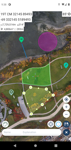
Tactical GPS app that includes GIS, measurement and planning tools
GPS and coordinate systems helper especially for military personnel.
It is also a complete helper for airsoft, mountaineering, trekking and hiking, cross running, scouting, hunting, fishing, geocaching, off-road navigation and all other outdoor activities and sports.
With satellite navigation systems such as GPS, GALILEO and GLONASS (GNSS) supported by your device and your sensors, you can see your most accurate position on different map layers.
⭐⭐Features⭐⭐
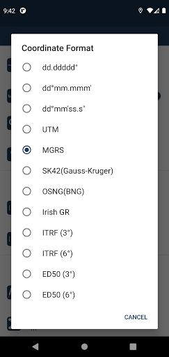
👉 Coordinate Indicator, finder and converter
Format options:
- D°M'S" (WGS84)
- Latitude/Longitude (WGS84)
- UTM (WGS84/NAD83),
- MGRS / U.S. National Grid (USNG) (WGS84/NAD83)
- SK42(Gauss Kruger)
- British National Grid(BNG-OSNG)
- Irish Grid Reference
- ED50 (6°-3°)
- ITRF (6°-3°)
👉 You can make colored markings on the map.
Markers,Polygons,Polylines,Circles
👉 Area & Distance measurement
Distance unit options: m , ft , mi , yd , nmi
Area unit options: m² , ha , ft², yd², mi²
👉 Elevation information
👉 Compass
Angular unit options: Degrees ,NATO mil, Warsaw Mil, Grad
👉 Map style options: (Road,Terrain,Satellite,Night Mode,Hybrid)
👉 KML viewer. (Export and import KML layers).
👉 GPS track recorder.