Mgrs & Utm Map
Mgrs & Utm Map Summary
Mgrs & Utm Map is a ad-supported Android app in Maps And Navigation by DakikTech. Released in Jul 2017 (8 years ago). It has about 2.3M+ installs and 21.9K ratings with a 4.66★ (excellent) average. Based on AppGoblin estimates, it reaches roughly 136.6K monthly active users and generates around $<10K monthly revenue (0% IAP / 100% ads). Store metadata: updated Apr 9, 2025, version 736.
Recent activity: 103.9K installs this week (132K over 4 weeks) showing exceptional growth , and 11 new ratings this week View trends →
Advertising: AppGoblin detected 1.00 monetized ad creatives shown inside the app.
Data tracking: SDKs and third-party integrations were last analyzed on Mar 31, 2026. The app's network data flows (API traffic to/from the app and its SDKs) were last crawled on Sep 4, 2025.
Store info: Last updated on Google Play on Apr 9, 2025 (version 736).
Mgrs & Utm Map was last scanned for SDKs 2026-03-31. Below is the overview of third party companies detected in the app. The full list of raw SDKs, app permissions and unknown SDKs is available here.
4.66★
Ratings: 21.9K
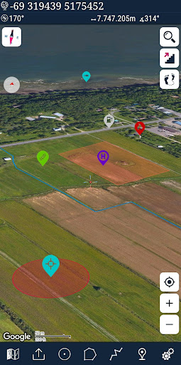
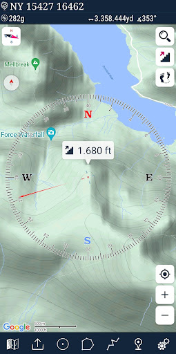
Screenshots


App Description
This app is military GPS coordinate systems helper. (MGRS, UTM & DMS Maps)
This application is GPS and coordinate systems helper especially for military personnel.
It is also a complete helper for mountaineering, trekking and hiking, cross running, scouting, hunting, fishing, geocaching, off-road navigation and all other outdoor activities and sports.
With satellite navigation systems such as GPS, GALILEO and GLONASS (GNSS) supported by your device and your sensors, you can see your most accurate position on different map layers.
Features:
* Easy and Faster
* Compass.
=> Compass on map (on the map that shows your direction)
=> Compass only (shows physical directions)
=> Angular units for compass (degrees ,NATO mil, Soviet Mil, Grad)
* Follow Mode
=> The center of the map follows your location while on the move.
* You can add and removing markers.
* Distance measure. (You can add custom route and calculate total distance)
* Area measure.(You can select an area on the map and calculate the area in square meters)
* You can see the altitude of your location.
* You can find the location according to Degree/Minute/Second , MGRS, UTM or Latitude/Longitude formats.
* Location (Coordinate) format options.
=> MGRS / U.S. National Grid (USNG) (WGS84/NAD83)
=> D°M'S" (WGS84)
=> Latitude/Longitude (WGS84)
=> UTM (WGS84/NAD83)
=> SK42(Gauss Kruger)
* Map type options (Road,Terrain,Satellite,Night Mode,Hybrid)
* You can share location coordinate.
* Distance unit options. (meter and feet).
* KML viewer. (Export and import KML layers).
* GPS track recorder.