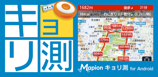
キョリ測 - 地図をタップでかんたん距離計測
キョリ測 - 地図をタップでかんたん距離計測 Summary
キョリ測 - 地図をタップでかんたん距離計測 is a ad-supported, with in-app purchases Android app in Travel And Local by ONE COMPATH CO., LTD.. Released in Mar 2012 (14 years ago). It has about 1.4M+ installs Based on AppGoblin estimates, it reaches roughly 9.2K monthly active users and generates around $<10K monthly revenue (64% IAP / 36% ads). Store metadata: updated Feb 12, 2026, version 95.
Recent activity: 4.8K installs this week (7.2K over 4 weeks) showing exceptional growth View trends →
Data tracking: SDKs and third-party integrations were last analyzed on Mar 1, 2026. The app's network data flows (API traffic to/from the app and its SDKs) were last crawled on Feb 17, 2026.
Store info: Last updated on Google Play on Feb 12, 2026 (version 95).
キョリ測 - 地図をタップでかんたん距離計測 was last scanned for SDKs 2026-03-01. Below is the overview of third party companies detected in the app. The full list of raw SDKs, app permissions and unknown SDKs is available here.
0★
Ratings: 0
Screenshots
App Description
Or tap the map, or tracing. The definitive edition of the distance measurement application that can freely create a route!
& # x1f600; Recommended points for Kyori measurement
・ You can easily create a route with abundant measurement patterns.
・ Accurately display route distance, route distance, and required time
・ Elevation display shows the height difference of the entire route
・ You can add a memo to the route for the information you care about.
・ You can save and share the created route
*** Main usage scenes ***
-------------------------
■ For daily health management
--Jogging / walking
Convert the distance traveled to calories burned. Also useful for health management and dieting.
■ For daily work
――When going out or traveling on a business trip
Create an efficient route before going out. You can rest assured that you can set a guideline for your travel time.
■ For holiday hobbies
--Climbing / hiking
You can check the altitude and the height difference of the route. By changing the walking speed, you can also measure the travel time of your child's feet.
--Cycling
You can find a comfortable route because you can visually see the slope of the slope.
■ For a new life
--Looking for a place to live
You can easily measure the distance to nearby spots such as stations and convenience stores.
--Commuting / school
You can check the shortest route from your home, such as a shortcut in a residential area.
■ For disaster prevention
Since you can see the altitude of the route, you can check the evacuation route in case of an emergency, so you can rest assured.
*** Main features ***
-------------------------
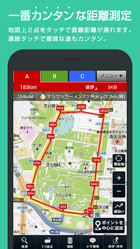
■ Distance measurement (route creation)
--Abundant measurement patterns
·Tap
Tap a point on the map to create a route
・ Pointer
Add a point in the center of the map
・ Trace
Easily draw a route by tracing the map
[Number of routes created]
Up to 3 patterns can be created at the same time by switching tabs
Easy route comparison
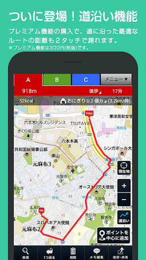
■ Roadside functions
――By tapping the two points, the starting point and the destination, you can automatically draw the optimum line along the road.
* Premium member-only function
* Maximum drawing distance of automatic route is 4km per section
■ Time required display / Calorie consumption calculation
--Displays time required and calories burned
--You can customize the movement speed in 0.01km increments.
――You can customize gender, age and weight
* The calorie consumption calculation will be accurate.
――You can choose the unit of calories burned from 14 types
[Moving method]
On foot
jogging
bicycle
car
[Calories burned]
rice ball
Anpan
Pancake
cookie
Soft cream
Mame Daifuku
Cheesecake
Coke 350ml
Draft beer
ramen
Beef curry
Hamburger
Bar of chocolate
Mashimashi Ramen
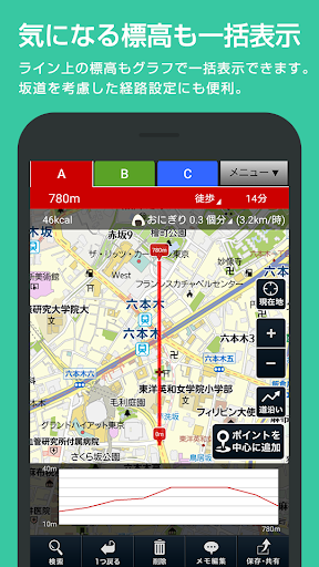
■ Elevation graph
--You can display the elevation of the entire route in a graph.
You can find a comfortable route because you can visually see the height difference of the route.
■ Memo function
--Up to 20 text memos can be registered on the route
■ Save and share routes
--You can save up to 100 measured routes.
* Mapion ID is required for routes with memos
--You can issue the URL of the measured route and share it by e-mail etc.
■ Hide ads
If you become a premium member, the advertisement will be hidden and you can measure the distance on a wider screen.
[Opinions / requests]
We look forward to your opinions and requests in order to aim for better service.
Please start the app and contact us from "Inquiry" in the setting menu.
[About inquiries]
We are closed on Saturdays, Sundays, national holidays, year-end and New Year holidays, and our holidays.
Please note that it may take several days or more to reply after consecutive holidays such as Golden Week and New Year holidays.
[Introduction]
About the use of location information
This service acquires location information, etc. for the purpose of improving the accuracy of the current location and map and improving the convenience of the service, and for the purpose of supporting advertisements, but the acquired information does not include personally identifiable information. We do not use them for personally identifiable purposes. Please be assured.
ONE COMPATH Co., Ltd. Handling of personal information
ONE COMPATH Co., Ltd. Terms of Use